You are here: Home > Network List > IU - Global Seismograph Network (GSN - IRIS/USGS) Stations List
> Station NWAO Narrogin, Australia > Earthquake Result Viewer
NWAO Narrogin, Australia - Earthquake Result Viewer
| Earthquake location: |
Solomon Islands |
| Earthquake latitude/longitude: |
-5.8/154.3 |
| Earthquake time(UTC): |
1995/08/16 (228) 23:10:28 GMT |
| Earthquake Depth: |
74 km |
| Earthquake Magnitude: |
6.1 MB, 7.2 MS, 7.2 UNKNOWN, 7.2 MW |
| Earthquake Catalog/Contributor: |
WHDF/NEIC |
|
| Network: |
IU Global Seismograph Network (GSN - IRIS/USGS) |
| Station: |
NWAO Narrogin, Australia |
| Lat/Lon: |
32.93 S/117.23 E |
| Elevation: |
265 m |
|
| Distance: |
43.8 deg |
| Az: |
227.07 deg |
| Baz: |
60.022 deg |
| Ray Param: |
0.07210672 |
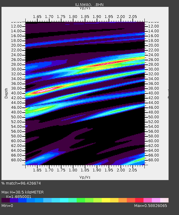
| Estimated Moho Depth: |
38.5 km |
| Estimated Crust Vp/Vs: |
1.69 |
| Assumed Crust Vp: |
6.419 km/s |
| Estimated Crust Vs: |
3.81 km/s |
| Estimated Crust Poisson's Ratio: |
0.23 |
|
| Radial Match: |
96.426674 % |
| Radial Bump: |
301 |
| Transverse Match: |
86.40139 % |
| Transverse Bump: |
400 |
| SOD ConfigId: |
6273 |
| Insert Time: |
2010-03-04 20:46:13.147 +0000 |
| GWidth: |
2.5 |
| Max Bumps: |
400 |
| Tol: |
0.001 |
|
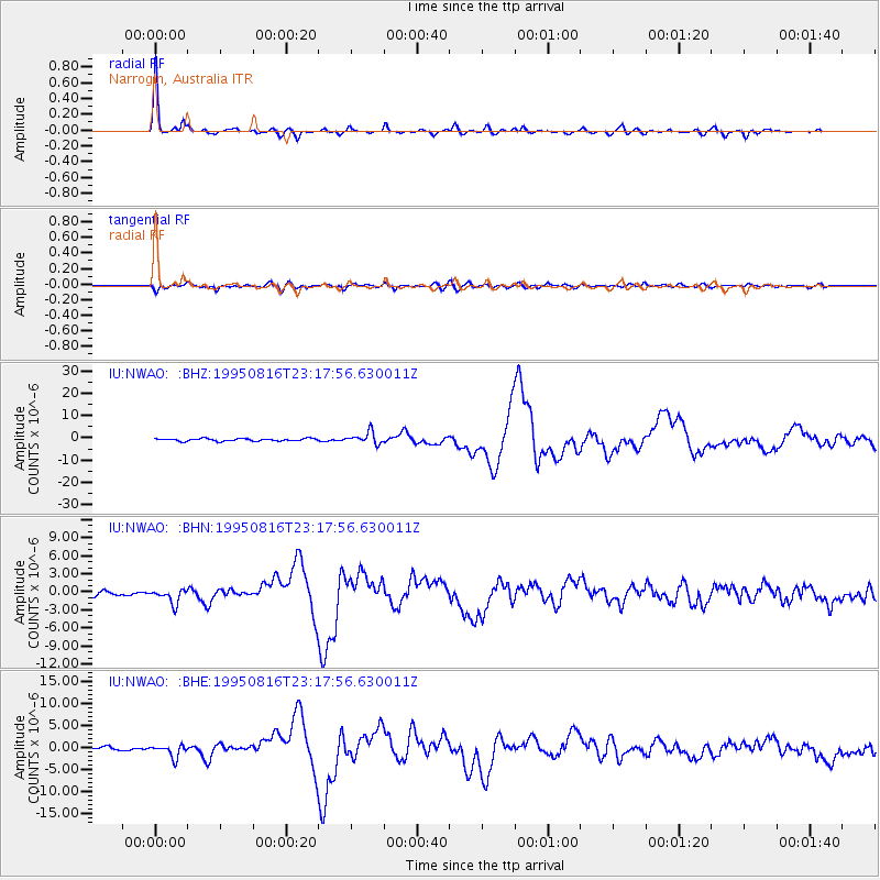
Signal To Noise
| Channel | StoN | STA | LTA |
| IU:NWAO: :BHN:19950816T23:17:56.630011Z | 2.7594898 | 1.206294E-6 | 4.3714388E-7 |
| IU:NWAO: :BHE:19950816T23:17:56.630011Z | 3.4383128 | 1.4425574E-6 | 4.1955386E-7 |
| IU:NWAO: :BHZ:19950816T23:17:56.630011Z | 4.5624633 | 2.6435991E-6 | 5.7942367E-7 |
| Arrivals |
| Ps | 4.4 SECOND |
| PpPs | 15 SECOND |
| PsPs/PpSs | 19 SECOND |


