You are here: Home > Network List > IU - Global Seismograph Network (GSN - IRIS/USGS) Stations List
> Station NWAO Narrogin, Australia > Earthquake Result Viewer
NWAO Narrogin, Australia - Earthquake Result Viewer
| Earthquake location: |
Taiwan Region |
| Earthquake latitude/longitude: |
21.9/121.5 |
| Earthquake time(UTC): |
1996/09/05 (249) 23:42:06 GMT |
| Earthquake Depth: |
20 km |
| Earthquake Magnitude: |
6.4 MB, 6.6 MS, 6.8 UNKNOWN, 6.8 ME |
| Earthquake Catalog/Contributor: |
WHDF/NEIC |
|
| Network: |
IU Global Seismograph Network (GSN - IRIS/USGS) |
| Station: |
NWAO Narrogin, Australia |
| Lat/Lon: |
32.93 S/117.23 E |
| Elevation: |
265 m |
|
| Distance: |
54.7 deg |
| Az: |
184.397 deg |
| Baz: |
4.856 deg |
| Ray Param: |
0.06528097 |
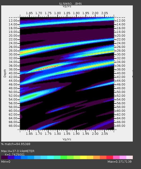
| Estimated Moho Depth: |
37.0 km |
| Estimated Crust Vp/Vs: |
1.74 |
| Assumed Crust Vp: |
6.419 km/s |
| Estimated Crust Vs: |
3.684 km/s |
| Estimated Crust Poisson's Ratio: |
0.25 |
|
| Radial Match: |
94.95369 % |
| Radial Bump: |
224 |
| Transverse Match: |
80.968315 % |
| Transverse Bump: |
400 |
| SOD ConfigId: |
6273 |
| Insert Time: |
2010-03-04 20:46:28.089 +0000 |
| GWidth: |
2.5 |
| Max Bumps: |
400 |
| Tol: |
0.001 |
|
Signal To Noise
| Channel | StoN | STA | LTA |
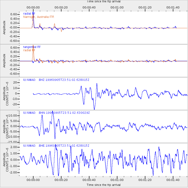
| IU:NWAO: :BHN:19960905T23:51:02.630029Z | 6.3100896 | 3.039313E-6 | 4.8165924E-7 |
| IU:NWAO: :BHE:19960905T23:51:02.628015Z | 1.0682018 | 3.9347668E-7 | 3.6835425E-7 |
| IU:NWAO: :BHZ:19960905T23:51:02.628015Z | 8.795714 | 5.441927E-6 | 6.1870213E-7 |
| Arrivals |
| Ps | 4.5 SECOND |
| PpPs | 15 SECOND |
| PsPs/PpSs | 19 SECOND |


