You are here: Home > Network List > IU - Global Seismograph Network (GSN - IRIS/USGS) Stations List
> Station NWAO Narrogin, Australia > Earthquake Result Viewer
NWAO Narrogin, Australia - Earthquake Result Viewer
| Earthquake location: |
Mariana Islands |
| Earthquake latitude/longitude: |
17.4/145.5 |
| Earthquake time(UTC): |
1996/06/09 (161) 01:12:16 GMT |
| Earthquake Depth: |
149 km |
| Earthquake Magnitude: |
6.0 MB, 5.9 MS, 6.5 UNKNOWN, 6.5 MW |
| Earthquake Catalog/Contributor: |
WHDF/NEIC |
|
| Network: |
IU Global Seismograph Network (GSN - IRIS/USGS) |
| Station: |
NWAO Narrogin, Australia |
| Lat/Lon: |
32.93 S/117.23 E |
| Elevation: |
265 m |
|
| Distance: |
56.9 deg |
| Az: |
208.348 deg |
| Baz: |
32.612 deg |
| Ray Param: |
0.06337375 |
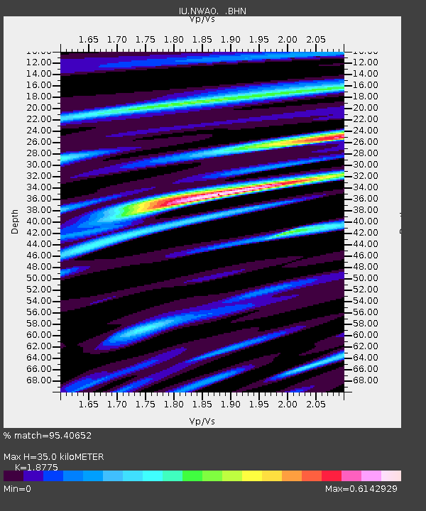
| Estimated Moho Depth: |
35.0 km |
| Estimated Crust Vp/Vs: |
1.88 |
| Assumed Crust Vp: |
6.419 km/s |
| Estimated Crust Vs: |
3.419 km/s |
| Estimated Crust Poisson's Ratio: |
0.30 |
|
| Radial Match: |
95.40652 % |
| Radial Bump: |
383 |
| Transverse Match: |
83.290436 % |
| Transverse Bump: |
400 |
| SOD ConfigId: |
6273 |
| Insert Time: |
2010-03-04 20:46:31.332 +0000 |
| GWidth: |
2.5 |
| Max Bumps: |
400 |
| Tol: |
0.001 |
|
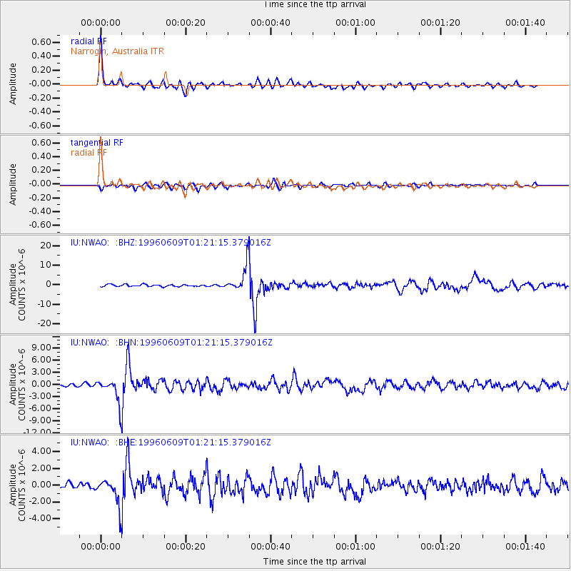
Signal To Noise
| Channel | StoN | STA | LTA |
| IU:NWAO: :BHN:19960609T01:21:15.379016Z | 8.629468 | 3.0846518E-6 | 3.574556E-7 |
| IU:NWAO: :BHE:19960609T01:21:15.379016Z | 4.859519 | 1.6448291E-6 | 3.384757E-7 |
| IU:NWAO: :BHZ:19960609T01:21:15.379016Z | 13.450796 | 6.767428E-6 | 5.0312474E-7 |
| Arrivals |
| Ps | 5.0 SECOND |
| PpPs | 15 SECOND |
| PsPs/PpSs | 20 SECOND |


