You are here: Home > Network List > IU - Global Seismograph Network (GSN - IRIS/USGS) Stations List
> Station NWAO Narrogin, Australia > Earthquake Result Viewer
NWAO Narrogin, Australia - Earthquake Result Viewer
| Earthquake location: |
Kuril Islands |
| Earthquake latitude/longitude: |
45.3/149.9 |
| Earthquake time(UTC): |
1996/02/07 (038) 21:36:45 GMT |
| Earthquake Depth: |
33 km |
| Earthquake Magnitude: |
6.3 MB, 7.0 MS, 7.2 UNKNOWN, 7.1 MW |
| Earthquake Catalog/Contributor: |
WHDF/NEIC |
|
| Network: |
IU Global Seismograph Network (GSN - IRIS/USGS) |
| Station: |
NWAO Narrogin, Australia |
| Lat/Lon: |
32.93 S/117.23 E |
| Elevation: |
265 m |
|
| Distance: |
83.3 deg |
| Az: |
207.203 deg |
| Baz: |
22.55 deg |
| Ray Param: |
0.046217144 |
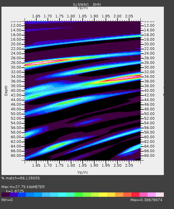
| Estimated Moho Depth: |
27.75 km |
| Estimated Crust Vp/Vs: |
1.67 |
| Assumed Crust Vp: |
6.419 km/s |
| Estimated Crust Vs: |
3.838 km/s |
| Estimated Crust Poisson's Ratio: |
0.22 |
|
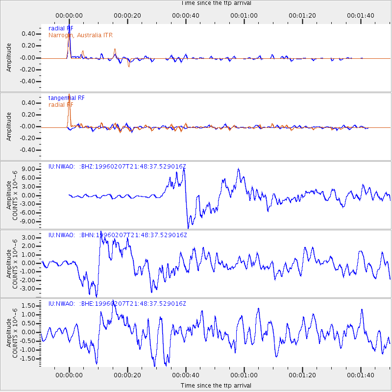
| Radial Match: |
96.129005 % |
| Radial Bump: |
265 |
| Transverse Match: |
76.33203 % |
| Transverse Bump: |
400 |
| SOD ConfigId: |
6273 |
| Insert Time: |
2010-03-04 20:46:34.560 +0000 |
| GWidth: |
2.5 |
| Max Bumps: |
400 |
| Tol: |
0.001 |
|
Signal To Noise
| Channel | StoN | STA | LTA |
| IU:NWAO: :BHN:19960207T21:48:37.529016Z | 4.5162606 | 1.1168719E-6 | 2.4730016E-7 |
| IU:NWAO: :BHE:19960207T21:48:37.529016Z | 1.6144028 | 4.5125248E-7 | 2.7951666E-7 |
| IU:NWAO: :BHZ:19960207T21:48:37.529016Z | 6.7927833 | 2.5475308E-6 | 3.750349E-7 |
| Arrivals |
| Ps | 3.0 SECOND |
| PpPs | 11 SECOND |
| PsPs/PpSs | 14 SECOND |


