You are here: Home > Network List > G - GEOSCOPE Stations List
> Station TAOE Taiohae, Marquises islands > Earthquake Result Viewer
TAOE Taiohae, Marquises islands - Earthquake Result Viewer
| Earthquake location: |
Solomon Islands |
| Earthquake latitude/longitude: |
-11.2/163.2 |
| Earthquake time(UTC): |
2015/05/22 (142) 23:59:33 GMT |
| Earthquake Depth: |
10 km |
| Earthquake Magnitude: |
6.8 MO |
| Earthquake Catalog/Contributor: |
NEIC PDE/NEIC ALERT |
|
| Network: |
G GEOSCOPE |
| Station: |
TAOE Taiohae, Marquises islands |
| Lat/Lon: |
8.85 S/140.15 W |
| Elevation: |
800 m |
|
| Distance: |
55.8 deg |
| Az: |
93.165 deg |
| Baz: |
262.529 deg |
| Ray Param: |
0.064573064 |
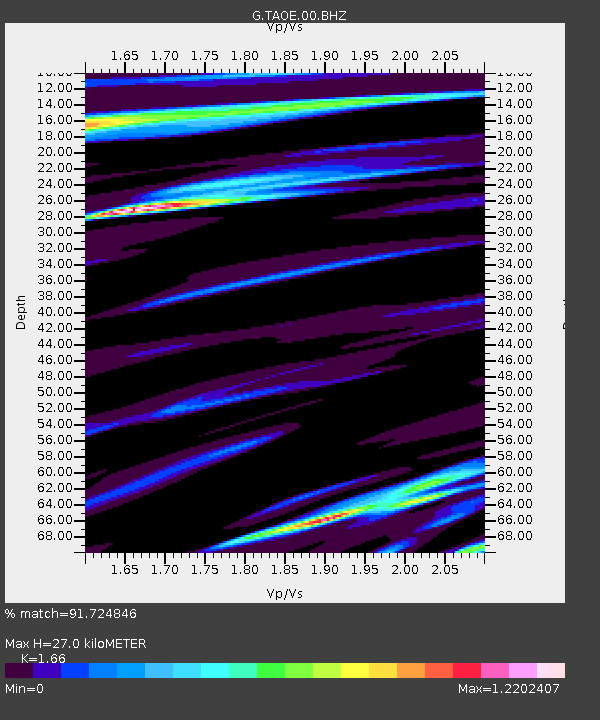
| Estimated Moho Depth: |
27.0 km |
| Estimated Crust Vp/Vs: |
1.66 |
| Assumed Crust Vp: |
4.24 km/s |
| Estimated Crust Vs: |
2.554 km/s |
| Estimated Crust Poisson's Ratio: |
0.22 |
|
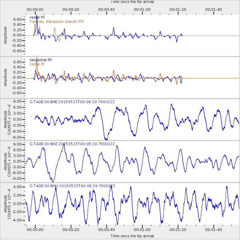
| Radial Match: |
91.724846 % |
| Radial Bump: |
266 |
| Transverse Match: |
72.70077 % |
| Transverse Bump: |
400 |
| SOD ConfigId: |
976571 |
| Insert Time: |
2015-06-06 00:07:36.108 +0000 |
| GWidth: |
2.5 |
| Max Bumps: |
400 |
| Tol: |
0.001 |
|
Signal To Noise
| Channel | StoN | STA | LTA |
| G:TAOE:00:BHZ:20150523T00:08:39.760022Z | 3.6115358 | 3.986072E-6 | 1.1037056E-6 |
| G:TAOE:00:BHN:20150523T00:08:39.760022Z | 1.3070678 | 1.5719529E-6 | 1.202656E-6 |
| G:TAOE:00:BHE:20150523T00:08:39.760022Z | 2.1933873 | 2.618183E-6 | 1.1936711E-6 |
| Arrivals |
| Ps | 4.3 SECOND |
| PpPs | 17 SECOND |
| PsPs/PpSs | 21 SECOND |


