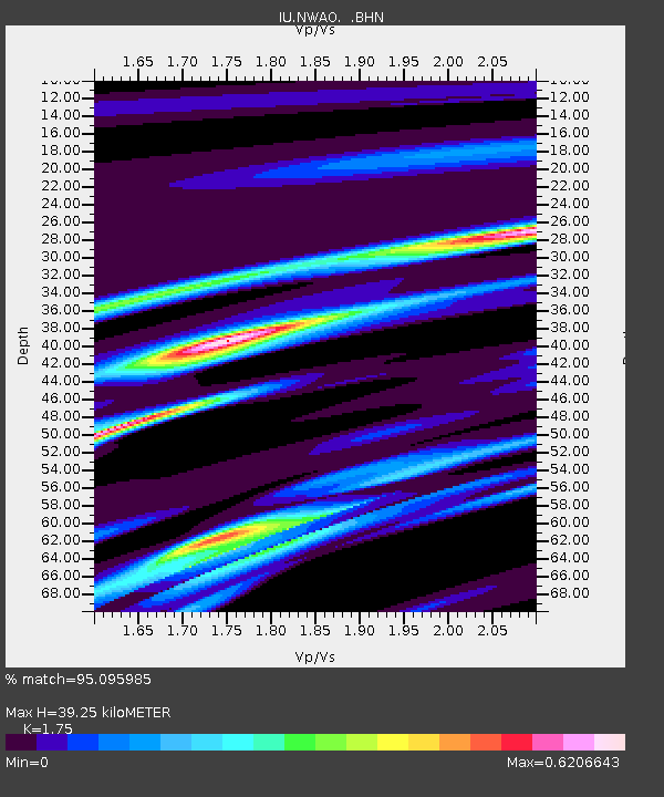
NWAO Narrogin, Australia - Earthquake Result Viewer
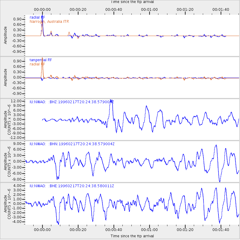
Earthquake location: Irian Jaya Region, Indonesia
Earthquake latitude/longitude: -0.9/136.1
Earthquake time(UTC): 1996/02/17 (048) 20:18:07 GMT
Earthquake Depth: 33 km
Earthquake Magnitude: 6.0 MB, 6.6 MS, 6.6 UNKNOWN
Earthquake Catalog/Contributor: WHDF/NEIC
Network: IU Global Seismograph Network (GSN - IRIS/USGS)
Station: NWAO Narrogin, Australia
Lat/Lon: 32.93 S/117.23 E
Elevation: 265 m
Distance: 36.5 deg
Az: 207.162 deg
Baz: 32.87 deg
Ray Param: 0.0766041
Estimated Moho Depth: 39.25 km
Estimated Crust Vp/Vs: 1.75
Assumed Crust Vp: 6.419 km/s
Estimated Crust Vs: 3.668 km/s
Estimated Crust Poisson's Ratio: 0.26
Radial Match: 95.095985 %
Radial Bump: 161
Transverse Match: 74.9197 %
Transverse Bump: 400
SOD ConfigId: 6273
Insert Time: 2010-03-04 20:46:47.735 +0000
GWidth: 2.5
Max Bumps: 400
Tol: 0.001

Signal To Noise

ChannelStoNSTALTA
IU:NWAO: :BHN:19960217T20:24:38.579004Z2.2901918.0540366E-73.516753E-7
IU:NWAO: :BHE:19960217T20:24:38.580011Z1.38176674.759911E-73.4448007E-7
IU:NWAO: :BHZ:19960217T20:24:38.579004Z1.89412651.1788344E-66.22363E-7
Arrivals
Ps4.9 SECOND
PpPs16 SECOND
PsPs/PpSs21 SECOND