You are here: Home > Network List > CI - Caltech Regional Seismic Network Stations List
> Station SWS Sam W. Stewart, Westmorland, CA, USA > Earthquake Result Viewer
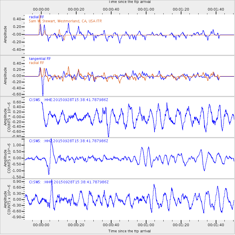
SWS Sam W. Stewart, Westmorland, CA, USA - Earthquake Result Viewer
*The percent match for this event was below the threshold and hence no stack was calculated.
| Earthquake location: |
Jujuy Province, Argentina |
| Earthquake latitude/longitude: |
-23.8/-66.6 |
| Earthquake time(UTC): |
2015/09/28 (271) 15:28:05 GMT |
| Earthquake Depth: |
219 km |
| Earthquake Magnitude: |
5.9 MWW, 6.0 MWB, 6.0 MWC |
| Earthquake Catalog/Contributor: |
NEIC PDE/NEIC COMCAT |
|
| Network: |
CI Caltech Regional Seismic Network |
| Station: |
SWS Sam W. Stewart, Westmorland, CA, USA |
| Lat/Lon: |
32.94 N/115.80 W |
| Elevation: |
140 m |
|
| Distance: |
73.4 deg |
| Az: |
318.362 deg |
| Baz: |
133.633 deg |
| Ray Param: |
$rayparam |
*The percent match for this event was below the threshold and hence was not used in the summary stack. |
|
| Radial Match: |
55.97096 % |
| Radial Bump: |
371 |
| Transverse Match: |
80.120384 % |
| Transverse Bump: |
326 |
| SOD ConfigId: |
7422571 |
| Insert Time: |
2019-04-21 01:10:37.909 +0000 |
| GWidth: |
2.5 |
| Max Bumps: |
400 |
| Tol: |
0.001 |
|
Signal To Noise
| Channel | StoN | STA | LTA |
| CI:SWS: :HHZ:20150928T15:38:41.787986Z | 5.64488 | 4.7576358E-7 | 8.428232E-8 |
| CI:SWS: :HHN:20150928T15:38:41.787986Z | 1.0670255 | 1.4801651E-7 | 1.387188E-7 |
| CI:SWS: :HHE:20150928T15:38:41.787986Z | 1.3368092 | 2.011461E-7 | 1.5046732E-7 |
| Arrivals |
| Ps | |
| PpPs | |
| PsPs/PpSs | |


