You are here: Home > Network List > IU - Global Seismograph Network (GSN - IRIS/USGS) Stations List
> Station NWAO Narrogin, Australia > Earthquake Result Viewer
NWAO Narrogin, Australia - Earthquake Result Viewer
| Earthquake location: |
Northern Molucca Sea |
| Earthquake latitude/longitude: |
1.7/126.1 |
| Earthquake time(UTC): |
1996/02/28 (059) 09:44:09 GMT |
| Earthquake Depth: |
103 km |
| Earthquake Magnitude: |
6.1 MB, 6.4 UNKNOWN, 6.4 MW |
| Earthquake Catalog/Contributor: |
WHDF/NEIC |
|
| Network: |
IU Global Seismograph Network (GSN - IRIS/USGS) |
| Station: |
NWAO Narrogin, Australia |
| Lat/Lon: |
32.93 S/117.23 E |
| Elevation: |
265 m |
|
| Distance: |
35.5 deg |
| Az: |
192.907 deg |
| Baz: |
15.395 deg |
| Ray Param: |
0.0768682 |
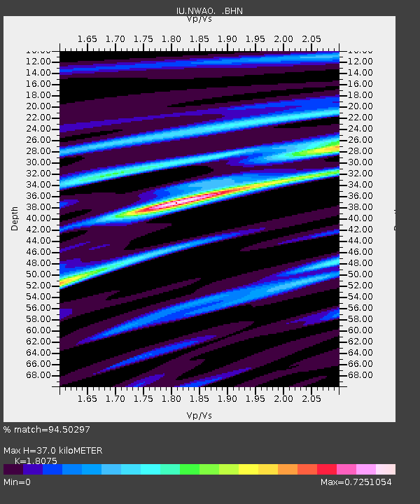
| Estimated Moho Depth: |
37.0 km |
| Estimated Crust Vp/Vs: |
1.81 |
| Assumed Crust Vp: |
6.419 km/s |
| Estimated Crust Vs: |
3.551 km/s |
| Estimated Crust Poisson's Ratio: |
0.28 |
|
| Radial Match: |
94.50297 % |
| Radial Bump: |
257 |
| Transverse Match: |
78.751656 % |
| Transverse Bump: |
400 |
| SOD ConfigId: |
6273 |
| Insert Time: |
2010-03-04 20:46:53.429 +0000 |
| GWidth: |
2.5 |
| Max Bumps: |
400 |
| Tol: |
0.001 |
|
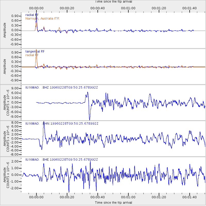
Signal To Noise
| Channel | StoN | STA | LTA |
| IU:NWAO: :BHN:19960228T09:50:25.678992Z | 21.844967 | 3.0893898E-6 | 1.4142341E-7 |
| IU:NWAO: :BHE:19960228T09:50:25.678992Z | 4.4008694 | 5.935315E-7 | 1.3486688E-7 |
| IU:NWAO: :BHZ:19960228T09:50:25.678992Z | 19.372747 | 4.1047406E-6 | 2.118822E-7 |
| Arrivals |
| Ps | 5.0 SECOND |
| PpPs | 15 SECOND |
| PsPs/PpSs | 20 SECOND |


