You are here: Home > Network List > IU - Global Seismograph Network (GSN - IRIS/USGS) Stations List
> Station NWAO Narrogin, Australia > Earthquake Result Viewer
NWAO Narrogin, Australia - Earthquake Result Viewer
| Earthquake location: |
Mindanao, Philippines |
| Earthquake latitude/longitude: |
9.6/126.3 |
| Earthquake time(UTC): |
1996/09/20 (264) 00:03:18 GMT |
| Earthquake Depth: |
33 km |
| Earthquake Magnitude: |
5.8 MB, 6.2 MS, 6.4 UNKNOWN, 6.4 MW |
| Earthquake Catalog/Contributor: |
WHDF/NEIC |
|
| Network: |
IU Global Seismograph Network (GSN - IRIS/USGS) |
| Station: |
NWAO Narrogin, Australia |
| Lat/Lon: |
32.93 S/117.23 E |
| Elevation: |
265 m |
|
| Distance: |
43.2 deg |
| Az: |
191.163 deg |
| Baz: |
13.122 deg |
| Ray Param: |
0.07266415 |
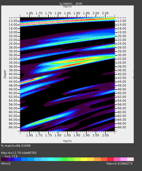
| Estimated Moho Depth: |
12.75 km |
| Estimated Crust Vp/Vs: |
1.72 |
| Assumed Crust Vp: |
6.419 km/s |
| Estimated Crust Vs: |
3.743 km/s |
| Estimated Crust Poisson's Ratio: |
0.24 |
|
| Radial Match: |
96.43499 % |
| Radial Bump: |
317 |
| Transverse Match: |
80.49445 % |
| Transverse Bump: |
400 |
| SOD ConfigId: |
6273 |
| Insert Time: |
2010-03-04 20:47:09.444 +0000 |
| GWidth: |
2.5 |
| Max Bumps: |
400 |
| Tol: |
0.001 |
|
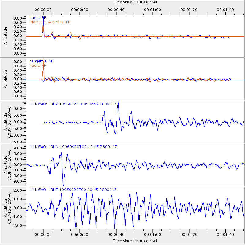
Signal To Noise
| Channel | StoN | STA | LTA |
| IU:NWAO: :BHN:19960920T00:10:45.280011Z | 6.0080056 | 2.0527384E-6 | 3.4166717E-7 |
| IU:NWAO: :BHE:19960920T00:10:45.280011Z | 1.9105544 | 4.292548E-7 | 2.2467553E-7 |
| IU:NWAO: :BHZ:19960920T00:10:45.280011Z | 8.836551 | 3.3761237E-6 | 3.8206352E-7 |
| Arrivals |
| Ps | 1.5 SECOND |
| PpPs | 5.0 SECOND |
| PsPs/PpSs | 6.6 SECOND |


