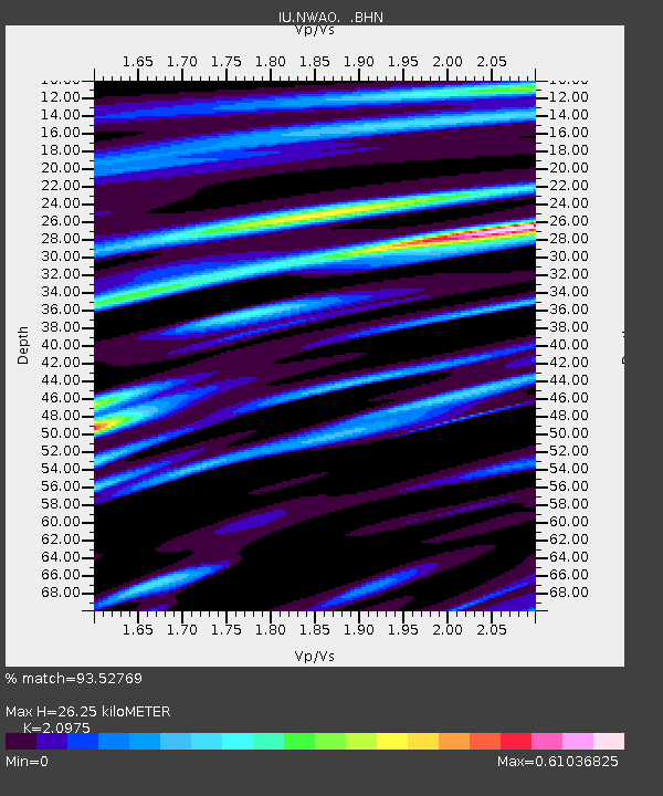
NWAO Narrogin, Australia - Earthquake Result Viewer
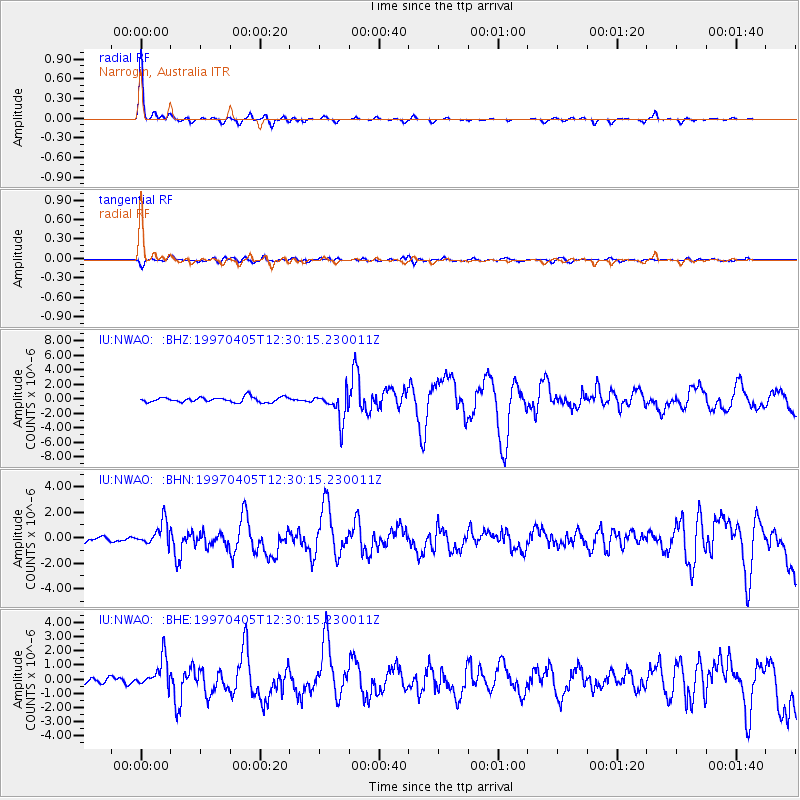
Earthquake location: Eastern New Guinea Reg., P.N.G.
Earthquake latitude/longitude: -6.5/147.4
Earthquake time(UTC): 1997/04/05 (095) 12:23:30 GMT
Earthquake Depth: 69 km
Earthquake Magnitude: 6.1 MB, 6.5 UNKNOWN, 6.4 MW
Earthquake Catalog/Contributor: WHDF/NEIC
Network: IU Global Seismograph Network (GSN - IRIS/USGS)
Station: NWAO Narrogin, Australia
Lat/Lon: 32.93 S/117.23 E
Elevation: 265 m
Distance: 38.4 deg
Az: 222.832 deg
Baz: 53.442 deg
Ray Param: 0.07534905
Estimated Moho Depth: 26.25 km
Estimated Crust Vp/Vs: 2.10
Assumed Crust Vp: 6.419 km/s
Estimated Crust Vs: 3.06 km/s
Estimated Crust Poisson's Ratio: 0.35
Radial Match: 93.52769 %
Radial Bump: 219
Transverse Match: 70.268074 %
Transverse Bump: 400
SOD ConfigId: 6273
Insert Time: 2010-03-04 20:47:23.431 +0000
GWidth: 2.5
Max Bumps: 400
Tol: 0.001

Signal To Noise

ChannelStoNSTALTA
IU:NWAO: :BHN:19970405T12:30:15.230011Z4.6998889.2149185E-71.9606676E-7
IU:NWAO: :BHE:19970405T12:30:15.230011Z4.1291941.0265102E-62.485982E-7
IU:NWAO: :BHZ:19970405T12:30:15.230011Z5.7155491.9873578E-63.4771074E-7
Arrivals
Ps4.8 SECOND
PpPs12 SECOND
PsPs/PpSs17 SECOND