You are here: Home > Network List > IU - Global Seismograph Network (GSN - IRIS/USGS) Stations List
> Station NWAO Narrogin, Australia > Earthquake Result Viewer
NWAO Narrogin, Australia - Earthquake Result Viewer
| Earthquake location: |
Mindanao, Philippines |
| Earthquake latitude/longitude: |
8.1/126.6 |
| Earthquake time(UTC): |
1997/09/15 (258) 13:05:42 GMT |
| Earthquake Depth: |
51 km |
| Earthquake Magnitude: |
5.8 MB, 5.7 MS, 6.1 UNKNOWN, 6.1 MW |
| Earthquake Catalog/Contributor: |
WHDF/NEIC |
|
| Network: |
IU Global Seismograph Network (GSN - IRIS/USGS) |
| Station: |
NWAO Narrogin, Australia |
| Lat/Lon: |
32.93 S/117.23 E |
| Elevation: |
265 m |
|
| Distance: |
41.8 deg |
| Az: |
191.911 deg |
| Baz: |
14.064 deg |
| Ray Param: |
0.073439285 |
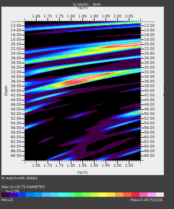
| Estimated Moho Depth: |
19.75 km |
| Estimated Crust Vp/Vs: |
2.08 |
| Assumed Crust Vp: |
6.419 km/s |
| Estimated Crust Vs: |
3.086 km/s |
| Estimated Crust Poisson's Ratio: |
0.35 |
|
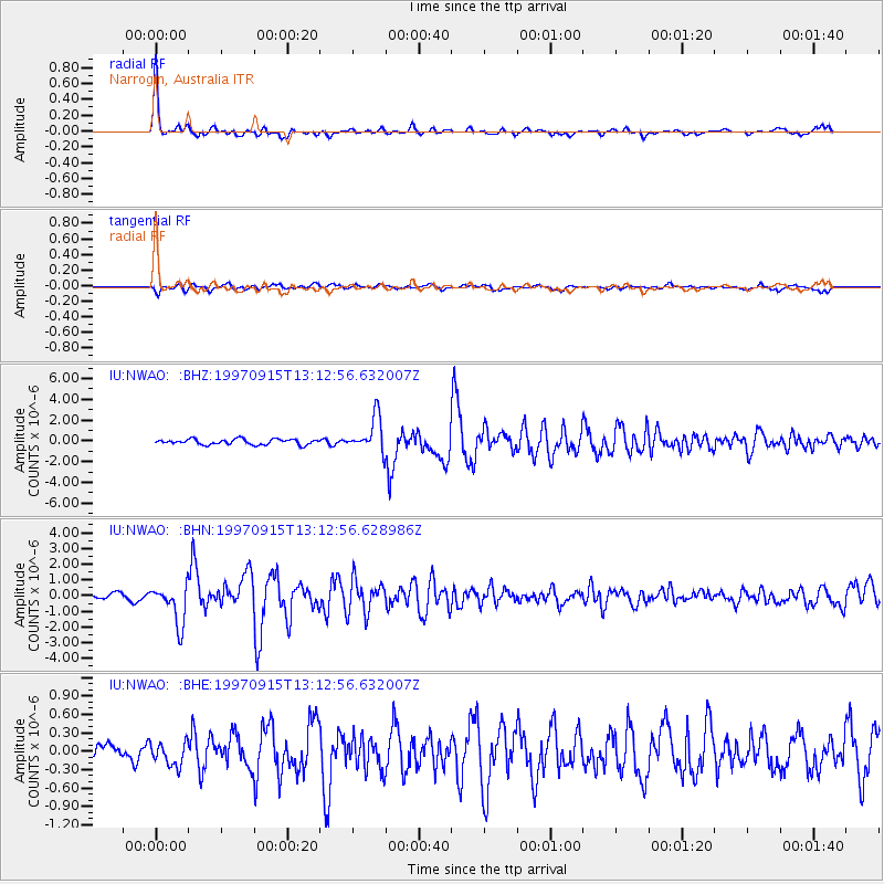
| Radial Match: |
94.49684 % |
| Radial Bump: |
297 |
| Transverse Match: |
85.38499 % |
| Transverse Bump: |
400 |
| SOD ConfigId: |
6273 |
| Insert Time: |
2010-03-04 20:47:43.246 +0000 |
| GWidth: |
2.5 |
| Max Bumps: |
400 |
| Tol: |
0.001 |
|
Signal To Noise
| Channel | StoN | STA | LTA |
| IU:NWAO: :BHN:19970915T13:12:56.628986Z | 7.1997986 | 1.2549057E-6 | 1.7429733E-7 |
| IU:NWAO: :BHE:19970915T13:12:56.632007Z | 1.5599859 | 1.9086899E-7 | 1.2235303E-7 |
| IU:NWAO: :BHZ:19970915T13:12:56.632007Z | 6.461901 | 1.6894387E-6 | 2.6144608E-7 |
| Arrivals |
| Ps | 3.5 SECOND |
| PpPs | 8.9 SECOND |
| PsPs/PpSs | 12 SECOND |


