You are here: Home > Network List > IU - Global Seismograph Network (GSN - IRIS/USGS) Stations List
> Station NWAO Narrogin, Australia > Earthquake Result Viewer
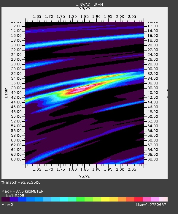
NWAO Narrogin, Australia - Earthquake Result Viewer
| Earthquake location: |
Balleny Islands Region |
| Earthquake latitude/longitude: |
-62.9/149.5 |
| Earthquake time(UTC): |
1998/03/25 (084) 03:12:25 GMT |
| Earthquake Depth: |
10 km |
| Earthquake Magnitude: |
6.6 MB, 8.0 MS, 8.3 UNKNOWN, 8.1 MW |
| Earthquake Catalog/Contributor: |
WHDF/NEIC |
|
| Network: |
IU Global Seismograph Network (GSN - IRIS/USGS) |
| Station: |
NWAO Narrogin, Australia |
| Lat/Lon: |
32.93 S/117.23 E |
| Elevation: |
265 m |
|
| Distance: |
36.2 deg |
| Az: |
310.511 deg |
| Baz: |
155.523 deg |
| Ray Param: |
0.07679491 |
| Estimated Moho Depth: |
37.5 km |
| Estimated Crust Vp/Vs: |
1.84 |
| Assumed Crust Vp: |
6.419 km/s |
| Estimated Crust Vs: |
3.484 km/s |
| Estimated Crust Poisson's Ratio: |
0.29 |
|
| Radial Match: |
93.912506 % |
| Radial Bump: |
211 |
| Transverse Match: |
84.36265 % |
| Transverse Bump: |
400 |
| SOD ConfigId: |
6273 |
| Insert Time: |
2010-03-04 20:47:53.091 +0000 |
| GWidth: |
2.5 |
| Max Bumps: |
400 |
| Tol: |
0.001 |
|

Signal To Noise
| Channel | StoN | STA | LTA |
| IU:NWAO: :BHN:19980325T03:18:57.230011Z | 6.6600327 | 4.5034512E-6 | 6.7619055E-7 |
| IU:NWAO: :BHE:19980325T03:18:57.230011Z | 6.2101026 | 2.8486445E-6 | 4.5871133E-7 |
| IU:NWAO: :BHZ:19980325T03:18:57.230011Z | 9.078727 | 7.338463E-6 | 8.0831416E-7 |
| Arrivals |
| Ps | 5.3 SECOND |
| PpPs | 15 SECOND |
| PsPs/PpSs | 21 SECOND |


