You are here: Home > Network List > IU - Global Seismograph Network (GSN - IRIS/USGS) Stations List
> Station NWAO Narrogin, Australia > Earthquake Result Viewer
NWAO Narrogin, Australia - Earthquake Result Viewer
| Earthquake location: |
Irian Jaya Region, Indonesia |
| Earthquake latitude/longitude: |
-0.9/136.1 |
| Earthquake time(UTC): |
1996/02/17 (048) 20:17:49 GMT |
| Earthquake Depth: |
33 km |
| Earthquake Magnitude: |
5.7 MB |
| Earthquake Catalog/Contributor: |
WHDF/NEIC |
|
| Network: |
IU Global Seismograph Network (GSN - IRIS/USGS) |
| Station: |
NWAO Narrogin, Australia |
| Lat/Lon: |
32.93 S/117.23 E |
| Elevation: |
265 m |
|
| Distance: |
36.4 deg |
| Az: |
207.248 deg |
| Baz: |
32.977 deg |
| Ray Param: |
0.07662396 |
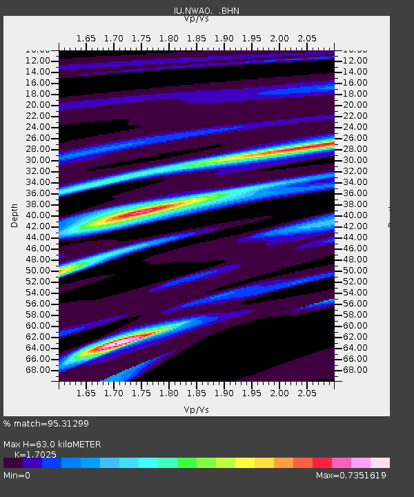
| Estimated Moho Depth: |
63.0 km |
| Estimated Crust Vp/Vs: |
1.70 |
| Assumed Crust Vp: |
6.419 km/s |
| Estimated Crust Vs: |
3.77 km/s |
| Estimated Crust Poisson's Ratio: |
0.24 |
|
| Radial Match: |
95.31299 % |
| Radial Bump: |
156 |
| Transverse Match: |
78.69664 % |
| Transverse Bump: |
400 |
| SOD ConfigId: |
4480 |
| Insert Time: |
2010-03-04 20:48:02.973 +0000 |
| GWidth: |
2.5 |
| Max Bumps: |
400 |
| Tol: |
0.001 |
|
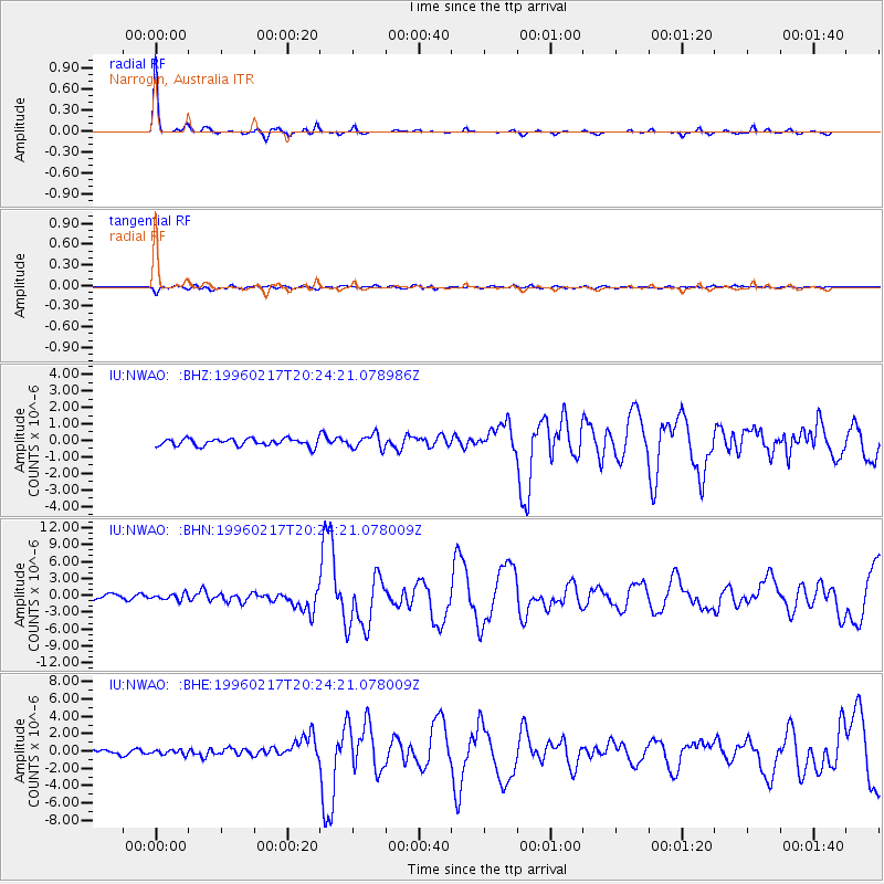
Signal To Noise
| Channel | StoN | STA | LTA |
| IU:NWAO: :BHN:19960217T20:24:21.078009Z | 1.5281833 | 5.4085666E-7 | 3.539213E-7 |
| IU:NWAO: :BHE:19960217T20:24:21.078009Z | 1.0771524 | 2.76834E-7 | 2.570054E-7 |
| IU:NWAO: :BHZ:19960217T20:24:21.078986Z | 1.9078443 | 4.2556113E-7 | 2.2305862E-7 |
| Arrivals |
| Ps | 7.5 SECOND |
| PpPs | 25 SECOND |
| PsPs/PpSs | 32 SECOND |


