You are here: Home > Network List > TA - USArray Transportable Network (new EarthScope stations) Stations List
> Station BGNE Belgrade, NE, USA > Earthquake Result Viewer
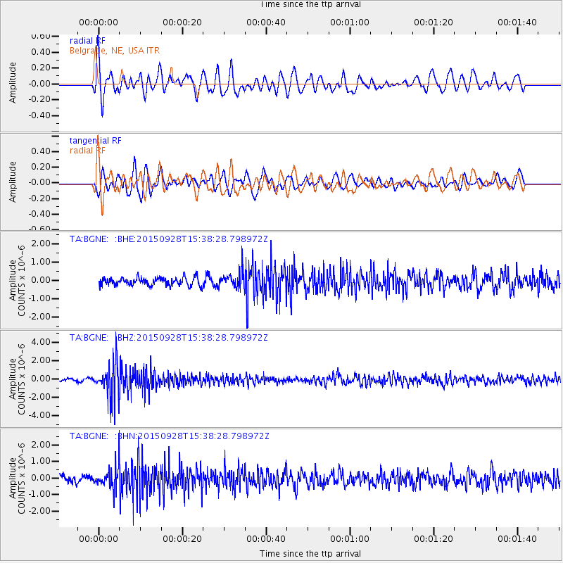
BGNE Belgrade, NE, USA - Earthquake Result Viewer
*The percent match for this event was below the threshold and hence no stack was calculated.
| Earthquake location: |
Jujuy Province, Argentina |
| Earthquake latitude/longitude: |
-23.8/-66.6 |
| Earthquake time(UTC): |
2015/09/28 (271) 15:28:05 GMT |
| Earthquake Depth: |
219 km |
| Earthquake Magnitude: |
5.9 MWW, 6.0 MWB, 6.0 MWC |
| Earthquake Catalog/Contributor: |
NEIC PDE/NEIC COMCAT |
|
| Network: |
TA USArray Transportable Network (new EarthScope stations) |
| Station: |
BGNE Belgrade, NE, USA |
| Lat/Lon: |
41.41 N/98.15 W |
| Elevation: |
573 m |
|
| Distance: |
71.2 deg |
| Az: |
335.416 deg |
| Baz: |
149.562 deg |
| Ray Param: |
$rayparam |
*The percent match for this event was below the threshold and hence was not used in the summary stack. |
|
| Radial Match: |
71.85582 % |
| Radial Bump: |
400 |
| Transverse Match: |
68.01961 % |
| Transverse Bump: |
400 |
| SOD ConfigId: |
7422571 |
| Insert Time: |
2019-04-21 01:15:32.516 +0000 |
| GWidth: |
2.5 |
| Max Bumps: |
400 |
| Tol: |
0.001 |
|
Signal To Noise
| Channel | StoN | STA | LTA |
| TA:BGNE: :BHZ:20150928T15:38:28.798972Z | 15.572035 | 1.9997763E-6 | 1.28421E-7 |
| TA:BGNE: :BHN:20150928T15:38:28.798972Z | 3.3130515 | 7.1257705E-7 | 2.1508178E-7 |
| TA:BGNE: :BHE:20150928T15:38:28.798972Z | 3.6098742 | 7.709116E-7 | 2.1355635E-7 |
| Arrivals |
| Ps | |
| PpPs | |
| PsPs/PpSs | |


