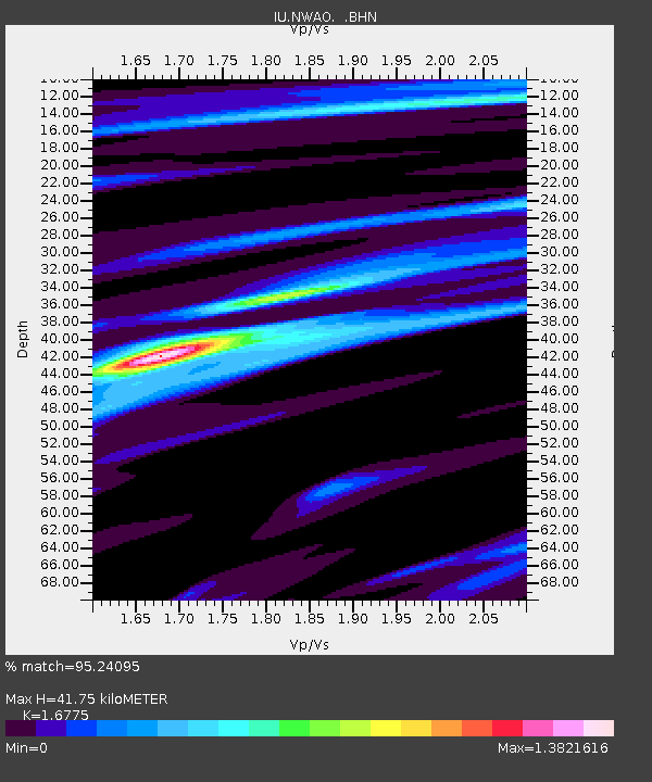
NWAO Narrogin, Australia - Earthquake Result Viewer
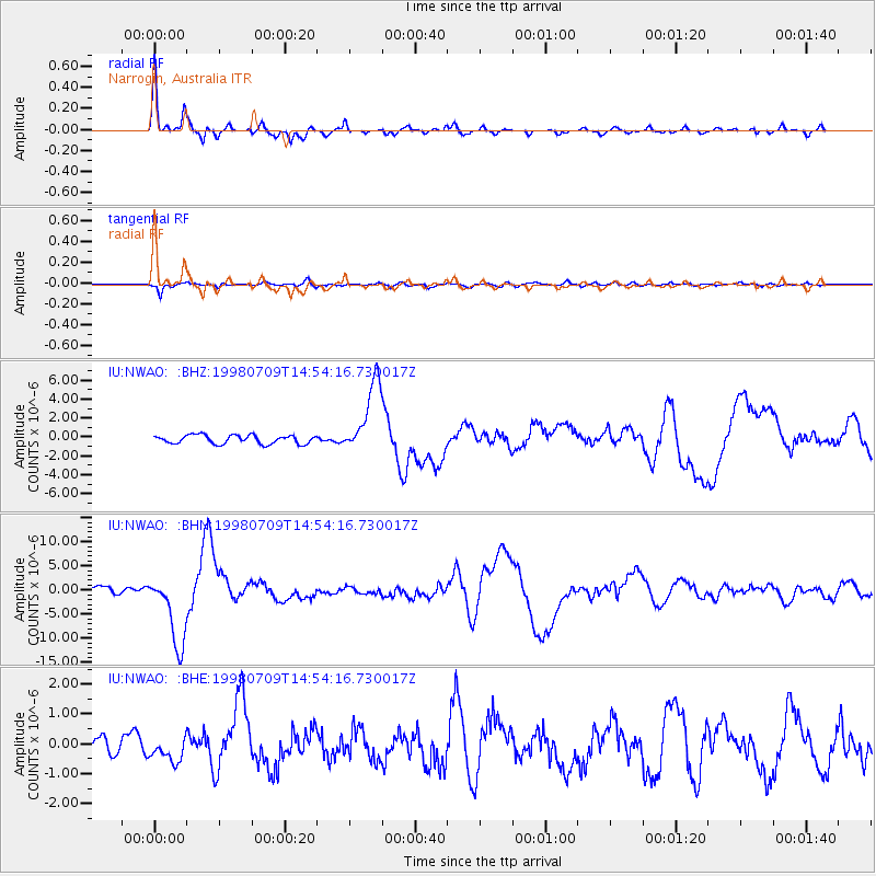
Earthquake location: Kermadec Islands, New Zealand
Earthquake latitude/longitude: -30.5/-179.0
Earthquake time(UTC): 1998/07/09 (190) 14:45:39 GMT
Earthquake Depth: 130 km
Earthquake Magnitude: 6.2 MB, 6.2 MS, 6.9 UNKNOWN, 6.4 ME
Earthquake Catalog/Contributor: WHDF/NEIC
Network: IU Global Seismograph Network (GSN - IRIS/USGS)
Station: NWAO Narrogin, Australia
Lat/Lon: 32.93 S/117.23 E
Elevation: 265 m
Distance: 53.6 deg
Az: 249.68 deg
Baz: 105.735 deg
Ray Param: 0.06558918
Estimated Moho Depth: 41.75 km
Estimated Crust Vp/Vs: 1.68
Assumed Crust Vp: 6.419 km/s
Estimated Crust Vs: 3.827 km/s
Estimated Crust Poisson's Ratio: 0.22
Radial Match: 95.24095 %
Radial Bump: 396
Transverse Match: 68.030334 %
Transverse Bump: 400
SOD ConfigId: 4480
Insert Time: 2010-03-04 20:48:08.200 +0000
GWidth: 2.5
Max Bumps: 400
Tol: 0.001

Signal To Noise

ChannelStoNSTALTA
IU:NWAO: :BHN:19980709T14:54:16.730017Z12.1517227.564916E-66.225386E-7
IU:NWAO: :BHE:19980709T14:54:16.730017Z1.23246614.0542304E-73.2895267E-7
IU:NWAO: :BHZ:19980709T14:54:16.730017Z8.5324123.8921035E-64.5615513E-7
Arrivals
Ps4.7 SECOND
PpPs16 SECOND
PsPs/PpSs21 SECOND