You are here: Home > Network List > WY - Yellowstone Wyoming Seismic Network Stations List
> Station YHH Holmes Hill, YNP, WY, USA > Earthquake Result Viewer
YHH Holmes Hill, YNP, WY, USA - Earthquake Result Viewer
| Earthquake location: |
Solomon Islands |
| Earthquake latitude/longitude: |
-11.2/163.2 |
| Earthquake time(UTC): |
2015/05/22 (142) 23:59:33 GMT |
| Earthquake Depth: |
10 km |
| Earthquake Magnitude: |
6.8 MO |
| Earthquake Catalog/Contributor: |
NEIC PDE/NEIC ALERT |
|
| Network: |
WY Yellowstone Wyoming Seismic Network |
| Station: |
YHH Holmes Hill, YNP, WY, USA |
| Lat/Lon: |
44.79 N/110.85 W |
| Elevation: |
2717 m |
|
| Distance: |
94.9 deg |
| Az: |
45.473 deg |
| Baz: |
259.27 deg |
| Ray Param: |
0.040920906 |
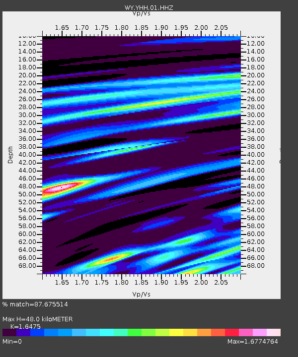
| Estimated Moho Depth: |
48.0 km |
| Estimated Crust Vp/Vs: |
1.65 |
| Assumed Crust Vp: |
6.35 km/s |
| Estimated Crust Vs: |
3.854 km/s |
| Estimated Crust Poisson's Ratio: |
0.21 |
|
| Radial Match: |
87.675514 % |
| Radial Bump: |
326 |
| Transverse Match: |
72.186005 % |
| Transverse Bump: |
355 |
| SOD ConfigId: |
976571 |
| Insert Time: |
2015-06-06 00:10:20.762 +0000 |
| GWidth: |
2.5 |
| Max Bumps: |
400 |
| Tol: |
0.001 |
|
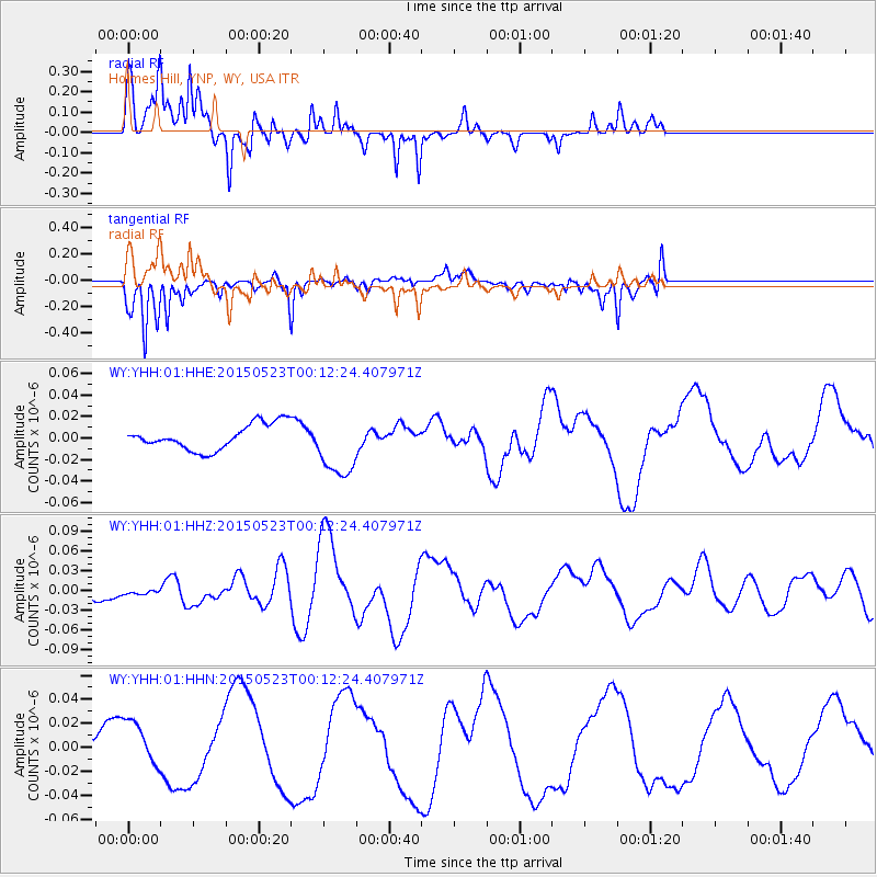
Signal To Noise
| Channel | StoN | STA | LTA |
| WY:YHH:01:HHZ:20150523T00:12:24.407971Z | 0.30681214 | 3.4280971E-9 | 1.1173277E-8 |
| WY:YHH:01:HHN:20150523T00:12:24.407971Z | 1.9575744 | 1.9877891E-8 | 1.01543485E-8 |
| WY:YHH:01:HHE:20150523T00:12:24.407971Z | 2.48472 | 2.9173403E-8 | 1.1741123E-8 |
| Arrivals |
| Ps | 5.0 SECOND |
| PpPs | 20 SECOND |
| PsPs/PpSs | 25 SECOND |


