You are here: Home > Network List > US - United States National Seismic Network Stations List
> Station LAO LASA Array, Montana, USA > Earthquake Result Viewer
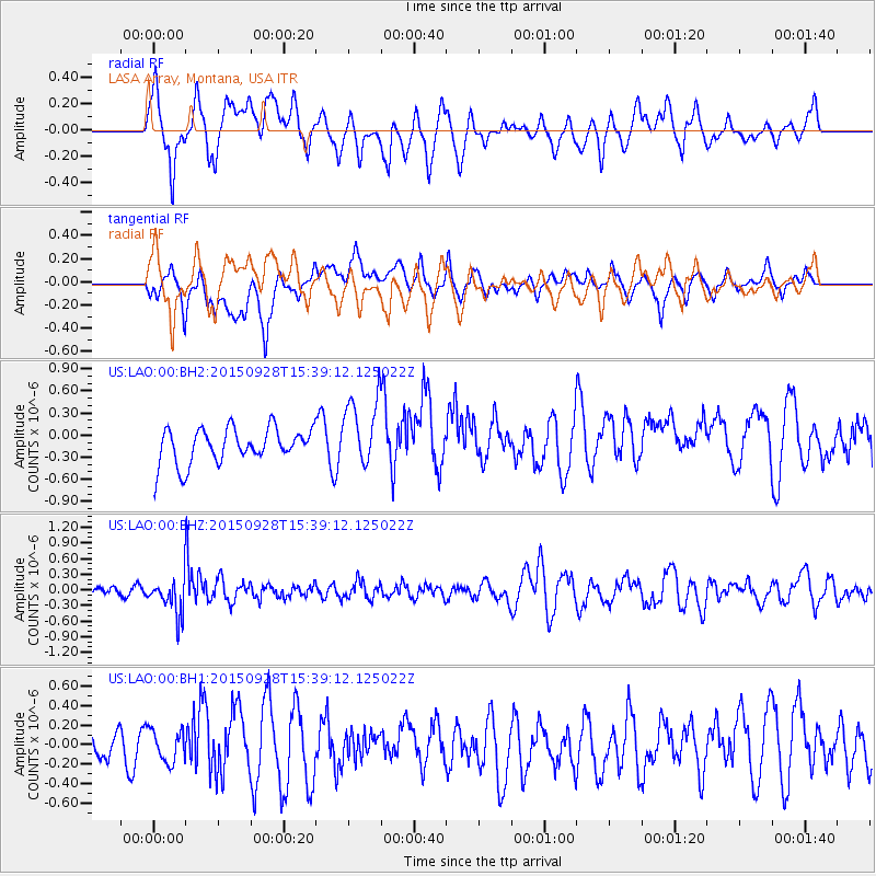
LAO LASA Array, Montana, USA - Earthquake Result Viewer
*The percent match for this event was below the threshold and hence no stack was calculated.
| Earthquake location: |
Jujuy Province, Argentina |
| Earthquake latitude/longitude: |
-23.8/-66.6 |
| Earthquake time(UTC): |
2015/09/28 (271) 15:28:05 GMT |
| Earthquake Depth: |
219 km |
| Earthquake Magnitude: |
5.9 MWW, 6.0 MWB, 6.0 MWC |
| Earthquake Catalog/Contributor: |
NEIC PDE/NEIC COMCAT |
|
| Network: |
US United States National Seismic Network |
| Station: |
LAO LASA Array, Montana, USA |
| Lat/Lon: |
46.69 N/106.22 W |
| Elevation: |
902 m |
|
| Distance: |
78.8 deg |
| Az: |
333.402 deg |
| Baz: |
143.434 deg |
| Ray Param: |
$rayparam |
*The percent match for this event was below the threshold and hence was not used in the summary stack. |
|
| Radial Match: |
62.59262 % |
| Radial Bump: |
400 |
| Transverse Match: |
48.430855 % |
| Transverse Bump: |
400 |
| SOD ConfigId: |
7422571 |
| Insert Time: |
2019-04-21 01:16:22.299 +0000 |
| GWidth: |
2.5 |
| Max Bumps: |
400 |
| Tol: |
0.001 |
|
Signal To Noise
| Channel | StoN | STA | LTA |
| US:LAO:00:BHZ:20150928T15:39:12.125022Z | 4.5633225 | 3.8154352E-7 | 8.36109E-8 |
| US:LAO:00:BH1:20150928T15:39:12.125022Z | 0.826023 | 1.6339355E-7 | 1.9780751E-7 |
| US:LAO:00:BH2:20150928T15:39:12.125022Z | 2.3308702 | 5.3069743E-7 | 2.276821E-7 |
| Arrivals |
| Ps | |
| PpPs | |
| PsPs/PpSs | |


