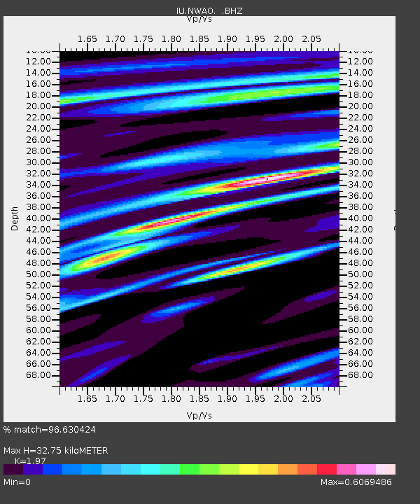
NWAO Narrogin, Australia - Earthquake Result Viewer
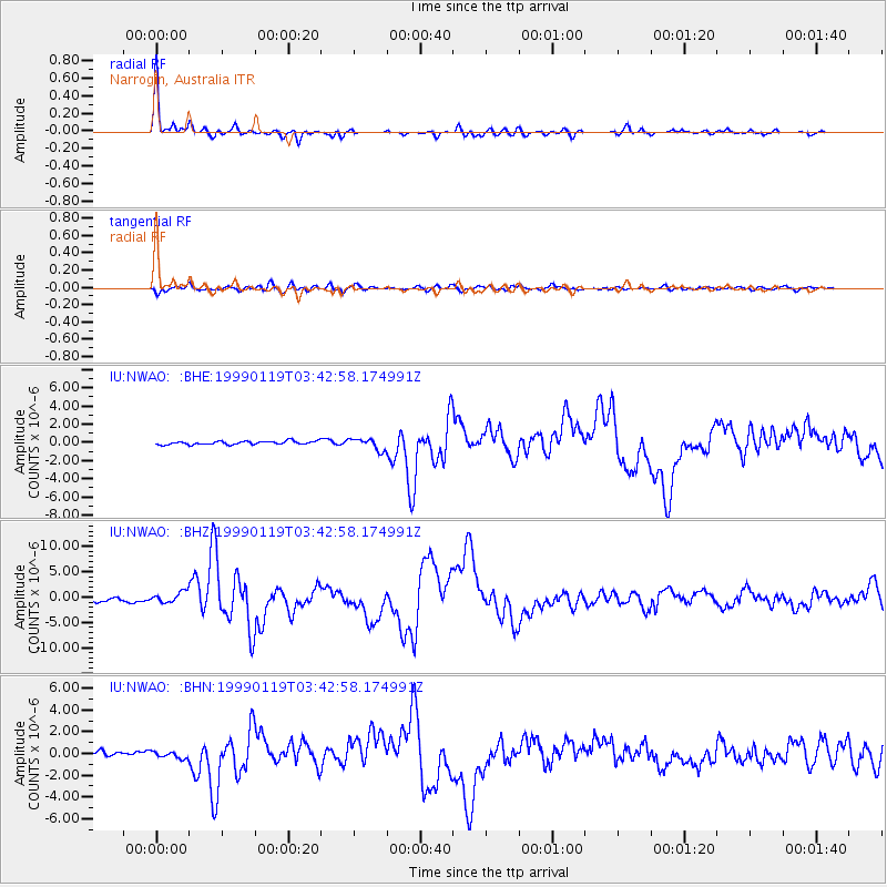
Earthquake location: New Ireland Region, P.N.G.
Earthquake latitude/longitude: -4.6/153.2
Earthquake time(UTC): 1999/01/19 (019) 03:35:33 GMT
Earthquake Depth: 114 km
Earthquake Magnitude: 5.8 MB, 6.4 MS, 7.0 MW, 6.5 ME
Earthquake Catalog/Contributor: WHDF/NEIC
Network: IU Global Seismograph Network (GSN - IRIS/USGS)
Station: NWAO Narrogin, Australia
Lat/Lon: 32.93 S/117.23 E
Elevation: 265 m
Distance: 43.8 deg
Az: 225.541 deg
Baz: 57.776 deg
Ray Param: 0.07189581
Estimated Moho Depth: 32.75 km
Estimated Crust Vp/Vs: 1.97
Assumed Crust Vp: 6.419 km/s
Estimated Crust Vs: 3.258 km/s
Estimated Crust Poisson's Ratio: 0.33
Radial Match: 96.630424 %
Radial Bump: 317
Transverse Match: 81.16498 %
Transverse Bump: 400
SOD ConfigId: 4480
Insert Time: 2010-03-04 20:48:33.366 +0000
GWidth: 2.5
Max Bumps: 400
Tol: 0.001

Signal To Noise

ChannelStoNSTALTA
IU:NWAO: :BHZ:19990119T03:42:58.174991Z3.13541961.0523157E-63.35622E-7
IU:NWAO: :BHN:19990119T03:42:58.174991Z1.13029922.9921114E-72.6471852E-7
IU:NWAO: :BHE:19990119T03:42:58.174991Z3.24739276.173245E-71.900985E-7
Arrivals
Ps5.2 SECOND
PpPs14 SECOND
PsPs/PpSs20 SECOND