You are here: Home > Network List > TA - USArray Transportable Network (new EarthScope stations) Stations List
> Station I23K Minto, Yukon-Koyukuk, AK, USA > Earthquake Result Viewer
I23K Minto, Yukon-Koyukuk, AK, USA - Earthquake Result Viewer
*The percent match for this event was below the threshold and hence no stack was calculated.
| Earthquake location: |
Guerrero, Mexico |
| Earthquake latitude/longitude: |
18.1/-101.3 |
| Earthquake time(UTC): |
2015/09/30 (273) 17:25:56 GMT |
| Earthquake Depth: |
65 km |
| Earthquake Magnitude: |
5.5 MB |
| Earthquake Catalog/Contributor: |
NEIC PDE/NEIC COMCAT |
|
| Network: |
TA USArray Transportable Network (new EarthScope stations) |
| Station: |
I23K Minto, Yukon-Koyukuk, AK, USA |
| Lat/Lon: |
65.15 N/149.36 W |
| Elevation: |
149 m |
|
| Distance: |
56.7 deg |
| Az: |
337.914 deg |
| Baz: |
122.191 deg |
| Ray Param: |
$rayparam |
*The percent match for this event was below the threshold and hence was not used in the summary stack. |
|
| Radial Match: |
63.65377 % |
| Radial Bump: |
400 |
| Transverse Match: |
61.148758 % |
| Transverse Bump: |
400 |
| SOD ConfigId: |
7422571 |
| Insert Time: |
2019-04-21 01:26:02.527 +0000 |
| GWidth: |
2.5 |
| Max Bumps: |
400 |
| Tol: |
0.001 |
|
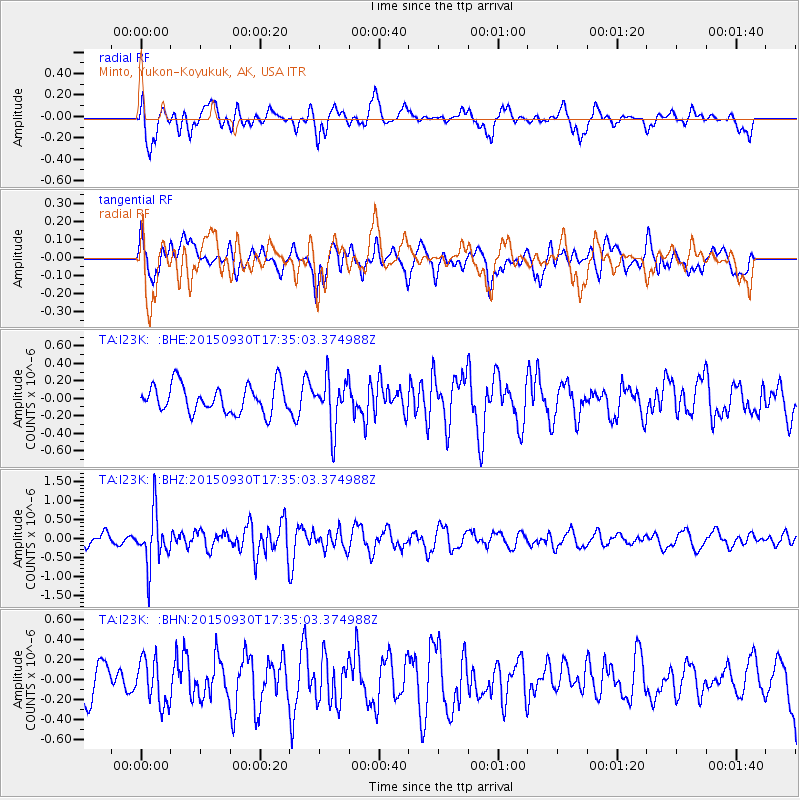
Signal To Noise
| Channel | StoN | STA | LTA |
| TA:I23K: :BHZ:20150930T17:35:03.374988Z | 4.337276 | 6.869243E-7 | 1.583769E-7 |
| TA:I23K: :BHN:20150930T17:35:03.374988Z | 1.368664 | 2.2732095E-7 | 1.6608968E-7 |
| TA:I23K: :BHE:20150930T17:35:03.374988Z | 1.7458135 | 2.7934482E-7 | 1.600084E-7 |
| Arrivals |
| Ps | |
| PpPs | |
| PsPs/PpSs | |


