You are here: Home > Network List > TA - USArray Transportable Network (new EarthScope stations) Stations List
> Station J26L Joseph Creek, AK, USA > Earthquake Result Viewer
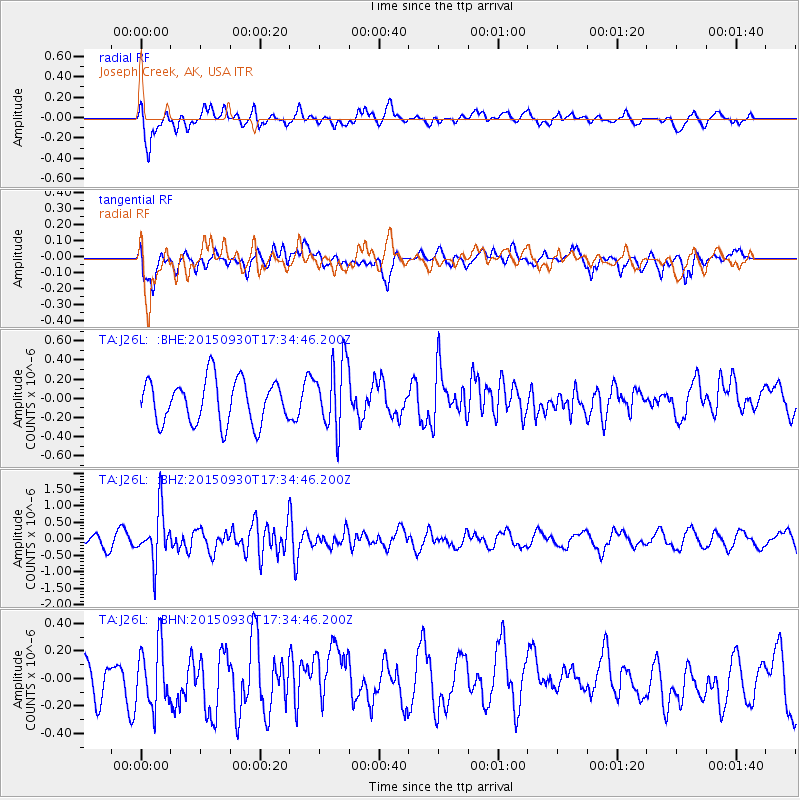
J26L Joseph Creek, AK, USA - Earthquake Result Viewer
*The percent match for this event was below the threshold and hence no stack was calculated.
| Earthquake location: |
Guerrero, Mexico |
| Earthquake latitude/longitude: |
18.1/-101.3 |
| Earthquake time(UTC): |
2015/09/30 (273) 17:25:56 GMT |
| Earthquake Depth: |
65 km |
| Earthquake Magnitude: |
5.5 MB |
| Earthquake Catalog/Contributor: |
NEIC PDE/NEIC COMCAT |
|
| Network: |
TA USArray Transportable Network (new EarthScope stations) |
| Station: |
J26L Joseph Creek, AK, USA |
| Lat/Lon: |
64.50 N/143.56 W |
| Elevation: |
1144 m |
|
| Distance: |
54.3 deg |
| Az: |
338.999 deg |
| Baz: |
128.046 deg |
| Ray Param: |
$rayparam |
*The percent match for this event was below the threshold and hence was not used in the summary stack. |
|
| Radial Match: |
74.90187 % |
| Radial Bump: |
400 |
| Transverse Match: |
53.568672 % |
| Transverse Bump: |
400 |
| SOD ConfigId: |
7422571 |
| Insert Time: |
2019-04-21 01:26:04.523 +0000 |
| GWidth: |
2.5 |
| Max Bumps: |
400 |
| Tol: |
0.001 |
|
Signal To Noise
| Channel | StoN | STA | LTA |
| TA:J26L: :BHZ:20150930T17:34:46.200Z | 5.815245 | 7.773872E-7 | 1.336809E-7 |
| TA:J26L: :BHN:20150930T17:34:46.200Z | 1.8162408 | 2.2319834E-7 | 1.2289028E-7 |
| TA:J26L: :BHE:20150930T17:34:46.200Z | 1.5600278 | 3.5233882E-7 | 2.258542E-7 |
| Arrivals |
| Ps | |
| PpPs | |
| PsPs/PpSs | |


