You are here: Home > Network List > US - United States National Seismic Network Stations List
> Station DGMT Dagmar, Montana, USA > Earthquake Result Viewer
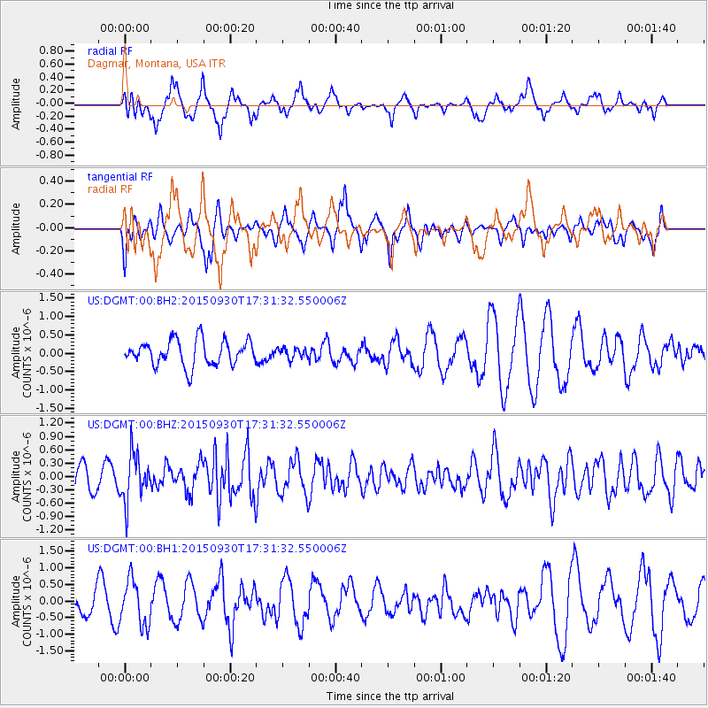
DGMT Dagmar, Montana, USA - Earthquake Result Viewer
*The percent match for this event was below the threshold and hence no stack was calculated.
| Earthquake location: |
Guerrero, Mexico |
| Earthquake latitude/longitude: |
18.1/-101.3 |
| Earthquake time(UTC): |
2015/09/30 (273) 17:25:56 GMT |
| Earthquake Depth: |
65 km |
| Earthquake Magnitude: |
5.5 MB |
| Earthquake Catalog/Contributor: |
NEIC PDE/NEIC COMCAT |
|
| Network: |
US United States National Seismic Network |
| Station: |
DGMT Dagmar, Montana, USA |
| Lat/Lon: |
48.47 N/104.20 W |
| Elevation: |
0.0 m |
|
| Distance: |
30.4 deg |
| Az: |
356.169 deg |
| Baz: |
174.52 deg |
| Ray Param: |
$rayparam |
*The percent match for this event was below the threshold and hence was not used in the summary stack. |
|
| Radial Match: |
71.28011 % |
| Radial Bump: |
400 |
| Transverse Match: |
54.654152 % |
| Transverse Bump: |
400 |
| SOD ConfigId: |
7422571 |
| Insert Time: |
2019-04-21 01:26:20.710 +0000 |
| GWidth: |
2.5 |
| Max Bumps: |
400 |
| Tol: |
0.001 |
|
Signal To Noise
| Channel | StoN | STA | LTA |
| US:DGMT:00:BHZ:20150930T17:31:32.550006Z | 1.9393815 | 5.361502E-7 | 2.7645422E-7 |
| US:DGMT:00:BH1:20150930T17:31:32.550006Z | 1.6826817 | 6.7409775E-7 | 4.006092E-7 |
| US:DGMT:00:BH2:20150930T17:31:32.550006Z | 0.41601795 | 1.430902E-7 | 3.43952E-7 |
| Arrivals |
| Ps | |
| PpPs | |
| PsPs/PpSs | |


