You are here: Home > Network List > IU - Global Seismograph Network (GSN - IRIS/USGS) Stations List
> Station XMAS Kiritimati Island, Republic of Kiribati > Earthquake Result Viewer
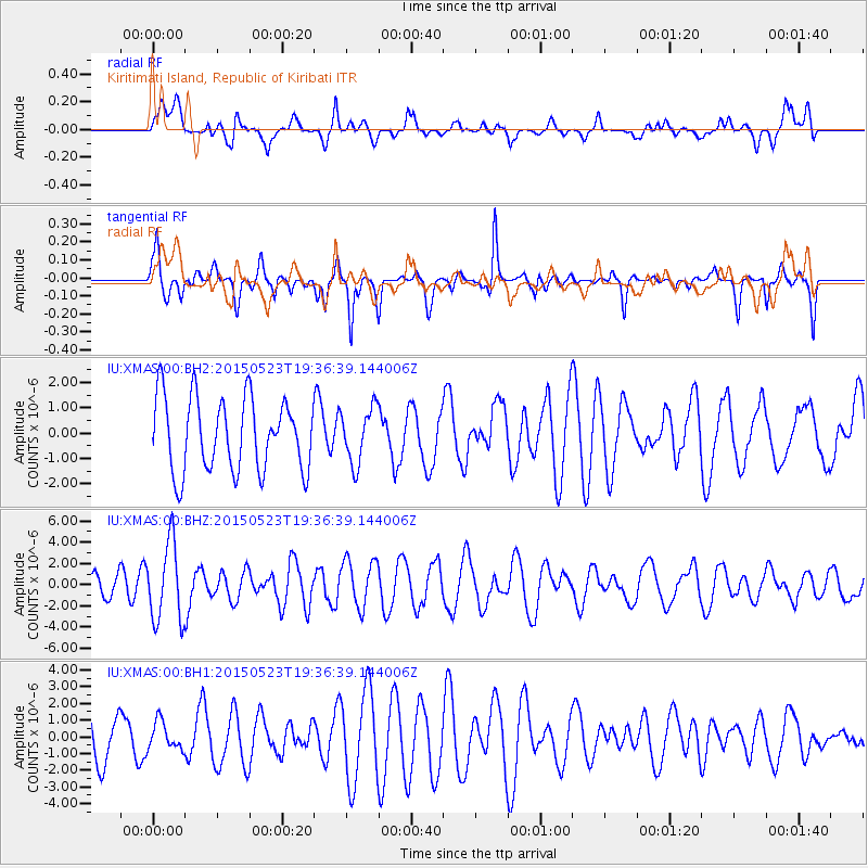
XMAS Kiritimati Island, Republic of Kiribati - Earthquake Result Viewer
*The percent match for this event was below the threshold and hence no stack was calculated.
| Earthquake location: |
New Britain Region, P.N.G. |
| Earthquake latitude/longitude: |
-4.8/152.7 |
| Earthquake time(UTC): |
2015/05/23 (143) 19:28:18 GMT |
| Earthquake Depth: |
51 km |
| Earthquake Magnitude: |
5.7 MB |
| Earthquake Catalog/Contributor: |
NEIC PDE/NEIC ALERT |
|
| Network: |
IU Global Seismograph Network (GSN - IRIS/USGS) |
| Station: |
XMAS Kiritimati Island, Republic of Kiribati |
| Lat/Lon: |
2.04 N/157.45 W |
| Elevation: |
20 m |
|
| Distance: |
50.3 deg |
| Az: |
83.336 deg |
| Baz: |
262.042 deg |
| Ray Param: |
$rayparam |
*The percent match for this event was below the threshold and hence was not used in the summary stack. |
|
| Radial Match: |
50.001755 % |
| Radial Bump: |
400 |
| Transverse Match: |
65.22652 % |
| Transverse Bump: |
382 |
| SOD ConfigId: |
976571 |
| Insert Time: |
2015-06-06 19:59:09.188 +0000 |
| GWidth: |
2.5 |
| Max Bumps: |
400 |
| Tol: |
0.001 |
|
Signal To Noise
| Channel | StoN | STA | LTA |
| IU:XMAS:00:BHZ:20150523T19:36:39.144006Z | 2.5506508 | 3.6789777E-6 | 1.4423682E-6 |
| IU:XMAS:00:BH1:20150523T19:36:39.144006Z | 0.6382713 | 8.328923E-7 | 1.304919E-6 |
| IU:XMAS:00:BH2:20150523T19:36:39.144006Z | 0.75344515 | 1.0868772E-6 | 1.4425433E-6 |
| Arrivals |
| Ps | |
| PpPs | |
| PsPs/PpSs | |


