You are here: Home > Network List > UW - Pacific Northwest Regional Seismic Network Stations List
> Station LEBA Lebam, WA, USA > Earthquake Result Viewer
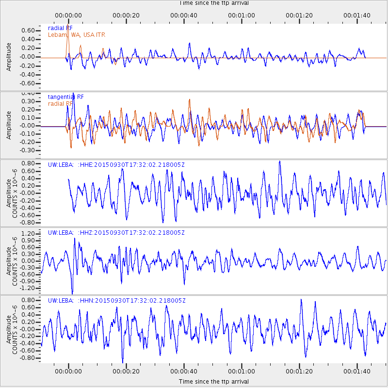
LEBA Lebam, WA, USA - Earthquake Result Viewer
*The percent match for this event was below the threshold and hence no stack was calculated.
| Earthquake location: |
Guerrero, Mexico |
| Earthquake latitude/longitude: |
18.1/-101.3 |
| Earthquake time(UTC): |
2015/09/30 (273) 17:25:56 GMT |
| Earthquake Depth: |
65 km |
| Earthquake Magnitude: |
5.5 MB |
| Earthquake Catalog/Contributor: |
NEIC PDE/NEIC COMCAT |
|
| Network: |
UW Pacific Northwest Regional Seismic Network |
| Station: |
LEBA Lebam, WA, USA |
| Lat/Lon: |
46.55 N/123.56 W |
| Elevation: |
73 m |
|
| Distance: |
33.8 deg |
| Az: |
331.951 deg |
| Baz: |
139.607 deg |
| Ray Param: |
$rayparam |
*The percent match for this event was below the threshold and hence was not used in the summary stack. |
|
| Radial Match: |
60.571865 % |
| Radial Bump: |
400 |
| Transverse Match: |
43.127354 % |
| Transverse Bump: |
400 |
| SOD ConfigId: |
7422571 |
| Insert Time: |
2019-04-21 01:26:33.821 +0000 |
| GWidth: |
2.5 |
| Max Bumps: |
400 |
| Tol: |
0.001 |
|
Signal To Noise
| Channel | StoN | STA | LTA |
| UW:LEBA: :HHZ:20150930T17:32:02.218005Z | 3.892759 | 6.108807E-7 | 1.5692743E-7 |
| UW:LEBA: :HHN:20150930T17:32:02.218005Z | 0.888739 | 2.2790196E-7 | 2.5643294E-7 |
| UW:LEBA: :HHE:20150930T17:32:02.218005Z | 1.3992364 | 4.0172986E-7 | 2.871065E-7 |
| Arrivals |
| Ps | |
| PpPs | |
| PsPs/PpSs | |


