You are here: Home > Network List > US - United States National Seismic Network Stations List
> Station HAWA Hanford, Washington, USA > Earthquake Result Viewer
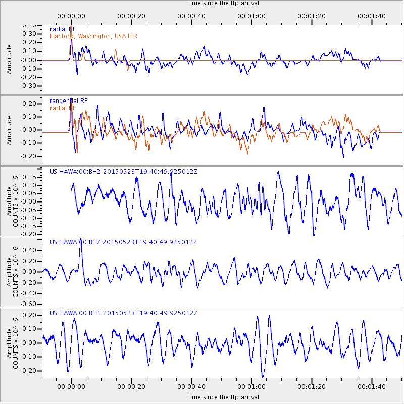
HAWA Hanford, Washington, USA - Earthquake Result Viewer
*The percent match for this event was below the threshold and hence no stack was calculated.
| Earthquake location: |
New Britain Region, P.N.G. |
| Earthquake latitude/longitude: |
-4.8/152.7 |
| Earthquake time(UTC): |
2015/05/23 (143) 19:28:18 GMT |
| Earthquake Depth: |
51 km |
| Earthquake Magnitude: |
5.7 MB |
| Earthquake Catalog/Contributor: |
NEIC PDE/NEIC ALERT |
|
| Network: |
US United States National Seismic Network |
| Station: |
HAWA Hanford, Washington, USA |
| Lat/Lon: |
46.39 N/119.53 W |
| Elevation: |
364 m |
|
| Distance: |
92.0 deg |
| Az: |
43.791 deg |
| Baz: |
265.088 deg |
| Ray Param: |
$rayparam |
*The percent match for this event was below the threshold and hence was not used in the summary stack. |
|
| Radial Match: |
58.230446 % |
| Radial Bump: |
400 |
| Transverse Match: |
48.775547 % |
| Transverse Bump: |
400 |
| SOD ConfigId: |
976571 |
| Insert Time: |
2015-06-06 20:00:08.826 +0000 |
| GWidth: |
2.5 |
| Max Bumps: |
400 |
| Tol: |
0.001 |
|
Signal To Noise
| Channel | StoN | STA | LTA |
| US:HAWA:00:BHZ:20150523T19:40:49.925012Z | 2.3146455 | 2.2975944E-7 | 9.926333E-8 |
| US:HAWA:00:BH1:20150523T19:40:49.925012Z | 1.7241479 | 1.2231513E-7 | 7.094236E-8 |
| US:HAWA:00:BH2:20150523T19:40:49.925012Z | 1.5590584 | 9.202977E-8 | 5.902907E-8 |
| Arrivals |
| Ps | |
| PpPs | |
| PsPs/PpSs | |


