You are here: Home > Network List > TA - USArray Transportable Network (new EarthScope stations) Stations List
> Station MSTX Muleshoe, TX, USA > Earthquake Result Viewer
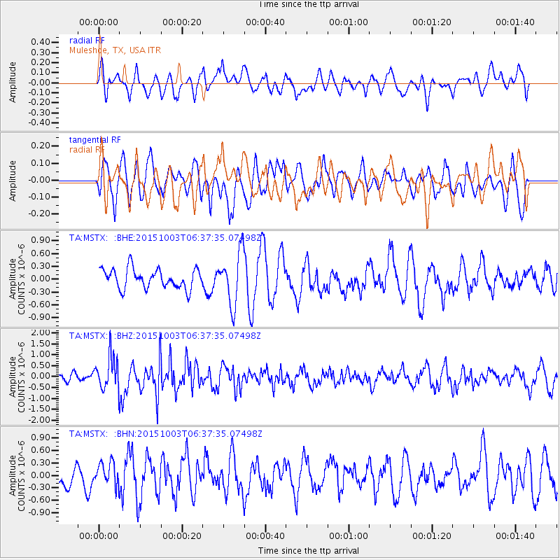
MSTX Muleshoe, TX, USA - Earthquake Result Viewer
*The percent match for this event was below the threshold and hence no stack was calculated.
| Earthquake location: |
Near Coast Of Central Chile |
| Earthquake latitude/longitude: |
-30.3/-71.6 |
| Earthquake time(UTC): |
2015/10/03 (276) 06:26:55 GMT |
| Earthquake Depth: |
40 km |
| Earthquake Magnitude: |
5.8 MWR |
| Earthquake Catalog/Contributor: |
NEIC PDE/NEIC COMCAT |
|
| Network: |
TA USArray Transportable Network (new EarthScope stations) |
| Station: |
MSTX Muleshoe, TX, USA |
| Lat/Lon: |
33.97 N/102.77 W |
| Elevation: |
1167 m |
|
| Distance: |
70.4 deg |
| Az: |
332.806 deg |
| Baz: |
151.606 deg |
| Ray Param: |
$rayparam |
*The percent match for this event was below the threshold and hence was not used in the summary stack. |
|
| Radial Match: |
51.684227 % |
| Radial Bump: |
400 |
| Transverse Match: |
65.57676 % |
| Transverse Bump: |
400 |
| SOD ConfigId: |
7422571 |
| Insert Time: |
2019-04-21 01:40:32.296 +0000 |
| GWidth: |
2.5 |
| Max Bumps: |
400 |
| Tol: |
0.001 |
|
Signal To Noise
| Channel | StoN | STA | LTA |
| TA:MSTX: :BHZ:20151003T06:37:35.07498Z | 3.8423681 | 7.733397E-7 | 2.0126643E-7 |
| TA:MSTX: :BHN:20151003T06:37:35.07498Z | 0.9782227 | 2.801423E-7 | 2.8637885E-7 |
| TA:MSTX: :BHE:20151003T06:37:35.07498Z | 2.6330016 | 6.0485814E-7 | 2.2972192E-7 |
| Arrivals |
| Ps | |
| PpPs | |
| PsPs/PpSs | |


