You are here: Home > Network List > TA - USArray Transportable Network (new EarthScope stations) Stations List
> Station J04D Umpqua National Forest, Toketee, OR, USA > Earthquake Result Viewer
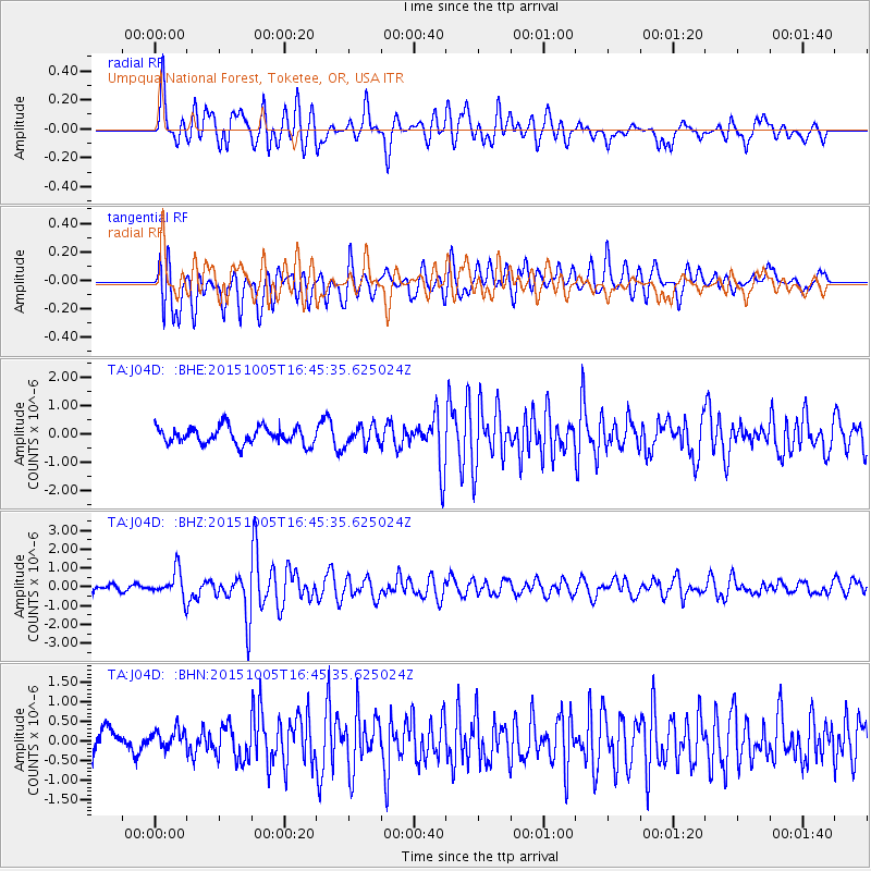
J04D Umpqua National Forest, Toketee, OR, USA - Earthquake Result Viewer
*The percent match for this event was below the threshold and hence no stack was calculated.
| Earthquake location: |
Near Coast Of Central Chile |
| Earthquake latitude/longitude: |
-30.3/-71.7 |
| Earthquake time(UTC): |
2015/10/05 (278) 16:33:26 GMT |
| Earthquake Depth: |
35 km |
| Earthquake Magnitude: |
6.0 MB |
| Earthquake Catalog/Contributor: |
NEIC PDE/NEIC ALERT |
|
| Network: |
TA USArray Transportable Network (new EarthScope stations) |
| Station: |
J04D Umpqua National Forest, Toketee, OR, USA |
| Lat/Lon: |
43.24 N/122.11 W |
| Elevation: |
1948 m |
|
| Distance: |
86.6 deg |
| Az: |
325.641 deg |
| Baz: |
138.089 deg |
| Ray Param: |
$rayparam |
*The percent match for this event was below the threshold and hence was not used in the summary stack. |
|
| Radial Match: |
66.98425 % |
| Radial Bump: |
400 |
| Transverse Match: |
70.7037 % |
| Transverse Bump: |
400 |
| SOD ConfigId: |
7422571 |
| Insert Time: |
2019-04-21 01:58:36.736 +0000 |
| GWidth: |
2.5 |
| Max Bumps: |
400 |
| Tol: |
0.001 |
|
Signal To Noise
| Channel | StoN | STA | LTA |
| TA:J04D: :BHZ:20151005T16:45:35.625024Z | 2.4976506 | 6.976737E-7 | 2.79332E-7 |
| TA:J04D: :BHN:20151005T16:45:35.625024Z | 0.76139396 | 2.525371E-7 | 3.3167726E-7 |
| TA:J04D: :BHE:20151005T16:45:35.625024Z | 1.3750982 | 4.0247284E-7 | 2.9268662E-7 |
| Arrivals |
| Ps | |
| PpPs | |
| PsPs/PpSs | |


