You are here: Home > Network List > TA - USArray Transportable Network (new EarthScope stations) Stations List
> Station O48A Farmland, IN, USA > Earthquake Result Viewer
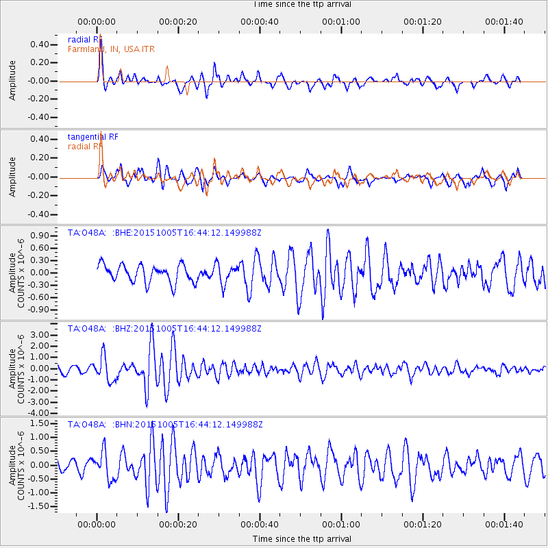
O48A Farmland, IN, USA - Earthquake Result Viewer
*The percent match for this event was below the threshold and hence no stack was calculated.
| Earthquake location: |
Near Coast Of Central Chile |
| Earthquake latitude/longitude: |
-30.3/-71.7 |
| Earthquake time(UTC): |
2015/10/05 (278) 16:33:26 GMT |
| Earthquake Depth: |
35 km |
| Earthquake Magnitude: |
6.0 MB |
| Earthquake Catalog/Contributor: |
NEIC PDE/NEIC ALERT |
|
| Network: |
TA USArray Transportable Network (new EarthScope stations) |
| Station: |
O48A Farmland, IN, USA |
| Lat/Lon: |
40.26 N/85.16 W |
| Elevation: |
300 m |
|
| Distance: |
71.3 deg |
| Az: |
349.143 deg |
| Baz: |
167.709 deg |
| Ray Param: |
$rayparam |
*The percent match for this event was below the threshold and hence was not used in the summary stack. |
|
| Radial Match: |
78.30084 % |
| Radial Bump: |
400 |
| Transverse Match: |
68.3446 % |
| Transverse Bump: |
400 |
| SOD ConfigId: |
7422571 |
| Insert Time: |
2019-04-21 01:58:55.619 +0000 |
| GWidth: |
2.5 |
| Max Bumps: |
400 |
| Tol: |
0.001 |
|
Signal To Noise
| Channel | StoN | STA | LTA |
| TA:O48A: :BHZ:20151005T16:44:12.149988Z | 3.2009242 | 1.1087416E-6 | 3.463817E-7 |
| TA:O48A: :BHN:20151005T16:44:12.149988Z | 2.06934 | 5.1165506E-7 | 2.472552E-7 |
| TA:O48A: :BHE:20151005T16:44:12.149988Z | 1.1223092 | 2.3285205E-7 | 2.0747584E-7 |
| Arrivals |
| Ps | |
| PpPs | |
| PsPs/PpSs | |


