You are here: Home > Network List > TA - USArray Transportable Network (new EarthScope stations) Stations List
> Station Z41A Richland Creek Farm, El Dorado, AR, USA > Earthquake Result Viewer
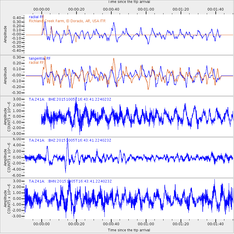
Z41A Richland Creek Farm, El Dorado, AR, USA - Earthquake Result Viewer
*The percent match for this event was below the threshold and hence no stack was calculated.
| Earthquake location: |
Near Coast Of Central Chile |
| Earthquake latitude/longitude: |
-30.3/-71.7 |
| Earthquake time(UTC): |
2015/10/05 (278) 16:33:26 GMT |
| Earthquake Depth: |
35 km |
| Earthquake Magnitude: |
6.0 MB |
| Earthquake Catalog/Contributor: |
NEIC PDE/NEIC ALERT |
|
| Network: |
TA USArray Transportable Network (new EarthScope stations) |
| Station: |
Z41A Richland Creek Farm, El Dorado, AR, USA |
| Lat/Lon: |
33.26 N/92.80 W |
| Elevation: |
62 m |
|
| Distance: |
66.3 deg |
| Az: |
340.739 deg |
| Baz: |
160.092 deg |
| Ray Param: |
$rayparam |
*The percent match for this event was below the threshold and hence was not used in the summary stack. |
|
| Radial Match: |
66.20032 % |
| Radial Bump: |
400 |
| Transverse Match: |
55.401577 % |
| Transverse Bump: |
351 |
| SOD ConfigId: |
7422571 |
| Insert Time: |
2019-04-21 01:59:11.704 +0000 |
| GWidth: |
2.5 |
| Max Bumps: |
400 |
| Tol: |
0.001 |
|
Signal To Noise
| Channel | StoN | STA | LTA |
| TA:Z41A: :BHZ:20151005T16:43:41.224023Z | 3.1991196 | 1.4583704E-6 | 4.558662E-7 |
| TA:Z41A: :BHN:20151005T16:43:41.224023Z | 1.0339712 | 7.8717125E-7 | 7.613087E-7 |
| TA:Z41A: :BHE:20151005T16:43:41.224023Z | 0.6764184 | 6.5945636E-7 | 9.749238E-7 |
| Arrivals |
| Ps | |
| PpPs | |
| PsPs/PpSs | |


