You are here: Home > Network List > IU - Global Seismograph Network (GSN - IRIS/USGS) Stations List
> Station SNZO South Karori, New Zealand > Earthquake Result Viewer
SNZO South Karori, New Zealand - Earthquake Result Viewer
| Earthquake location: |
New Ireland Region, P.N.G. |
| Earthquake latitude/longitude: |
-5.1/153.2 |
| Earthquake time(UTC): |
2000/11/16 (321) 05:21:22 GMT |
| Earthquake Depth: |
33 km |
| Earthquake Magnitude: |
6.0 MB |
| Earthquake Catalog/Contributor: |
WHDF/NEIC |
|
| Network: |
IU Global Seismograph Network (GSN - IRIS/USGS) |
| Station: |
SNZO South Karori, New Zealand |
| Lat/Lon: |
41.31 S/174.70 E |
| Elevation: |
62 m |
|
| Distance: |
40.9 deg |
| Az: |
155.087 deg |
| Baz: |
326.15 deg |
| Ray Param: |
0.0740734 |
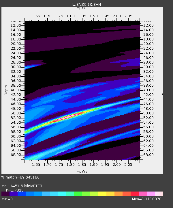
| Estimated Moho Depth: |
51.5 km |
| Estimated Crust Vp/Vs: |
1.78 |
| Assumed Crust Vp: |
6.461 km/s |
| Estimated Crust Vs: |
3.625 km/s |
| Estimated Crust Poisson's Ratio: |
0.27 |
|
| Radial Match: |
89.045166 % |
| Radial Bump: |
310 |
| Transverse Match: |
89.00531 % |
| Transverse Bump: |
287 |
| SOD ConfigId: |
3744 |
| Insert Time: |
2010-03-04 20:53:08.284 +0000 |
| GWidth: |
2.5 |
| Max Bumps: |
400 |
| Tol: |
0.001 |
|
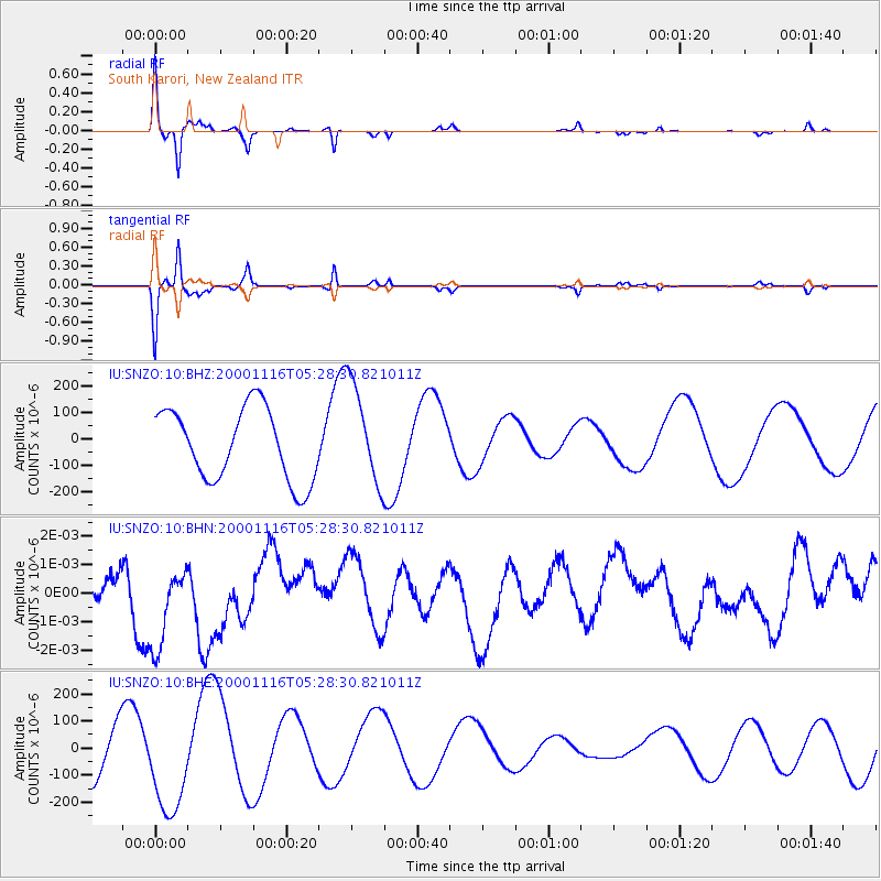
Signal To Noise
| Channel | StoN | STA | LTA |
| IU:SNZO:10:BHN:20001116T05:28:30.821011Z | 0.9576279 | 1.6785838E-9 | 1.752856E-9 |
| IU:SNZO:10:BHE:20001116T05:28:30.821011Z | 1.5635328 | 1.8804053E-4 | 1.2026644E-4 |
| IU:SNZO:10:BHZ:20001116T05:28:30.821011Z | 1.3972676 | 1.9011949E-4 | 1.3606521E-4 |
| Arrivals |
| Ps | 6.7 SECOND |
| PpPs | 21 SECOND |
| PsPs/PpSs | 27 SECOND |


