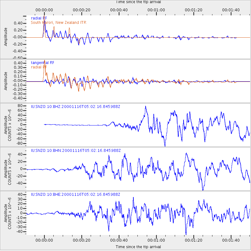
SNZO South Karori, New Zealand - Earthquake Result Viewer
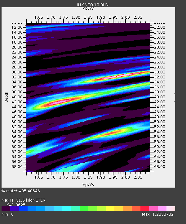
Earthquake location: New Ireland Region, P.N.G.
Earthquake latitude/longitude: -4.0/152.2
Earthquake time(UTC): 2000/11/16 (321) 04:54:56 GMT
Earthquake Depth: 33 km
Earthquake Magnitude: 6.0 MB, 8.2 MS, 8.0 MW, 8.0 ME
Earthquake Catalog/Contributor: WHDF/NEIC
Network: IU Global Seismograph Network (GSN - IRIS/USGS)
Station: SNZO South Karori, New Zealand
Lat/Lon: 41.31 S/174.70 E
Elevation: 62 m
Distance: 42.3 deg
Az: 154.602 deg
Baz: 325.39 deg
Ray Param: 0.073186584
Estimated Moho Depth: 31.5 km
Estimated Crust Vp/Vs: 1.96
Assumed Crust Vp: 6.461 km/s
Estimated Crust Vs: 3.292 km/s
Estimated Crust Poisson's Ratio: 0.32
Radial Match: 95.40546 %
Radial Bump: 400
Transverse Match: 81.908775 %
Transverse Bump: 400
SOD ConfigId: 3744
Insert Time: 2010-03-04 20:53:10.014 +0000
GWidth: 2.5
Max Bumps: 400
Tol: 0.001

Signal To Noise

ChannelStoNSTALTA
IU:SNZO:10:BHN:20001116T05:02:16.845988Z1.30408811.0170914E-67.799254E-7
IU:SNZO:10:BHE:20001116T05:02:16.845988Z1.10237421.1609741E-61.0531579E-6
IU:SNZO:10:BHZ:20001116T05:02:16.845988Z1.40367251.758337E-61.252669E-6
Arrivals
Ps5.0 SECOND
PpPs14 SECOND
PsPs/PpSs19 SECOND