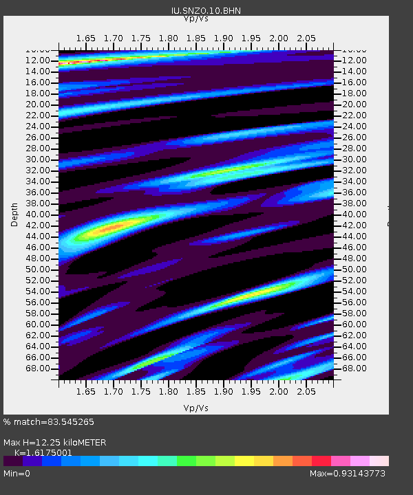
SNZO South Karori, New Zealand - Earthquake Result Viewer
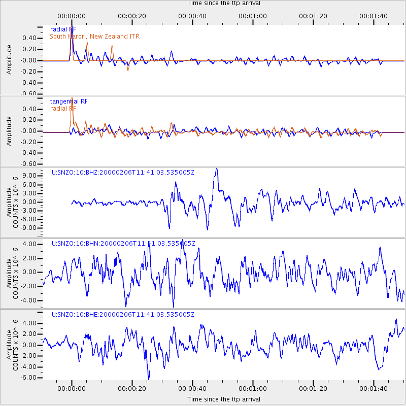
Earthquake location: New Britain Region, P.N.G.
Earthquake latitude/longitude: -5.8/150.9
Earthquake time(UTC): 2000/02/06 (037) 11:33:52 GMT
Earthquake Depth: 33 km
Earthquake Magnitude: 6.6 MB, 6.8 MS, 6.6 MW, 6.3 ME
Earthquake Catalog/Contributor: WHDF/NEIC
Network: IU Global Seismograph Network (GSN - IRIS/USGS)
Station: SNZO South Karori, New Zealand
Lat/Lon: 41.31 S/174.70 E
Elevation: 62 m
Distance: 41.2 deg
Az: 152.496 deg
Baz: 322.42 deg
Ray Param: 0.07385723
Estimated Moho Depth: 12.25 km
Estimated Crust Vp/Vs: 1.62
Assumed Crust Vp: 6.461 km/s
Estimated Crust Vs: 3.995 km/s
Estimated Crust Poisson's Ratio: 0.19
Radial Match: 83.545265 %
Radial Bump: 400
Transverse Match: 44.11458 %
Transverse Bump: 400
SOD ConfigId: 3744
Insert Time: 2010-03-04 20:53:12.484 +0000
GWidth: 2.5
Max Bumps: 400
Tol: 0.001

Signal To Noise

ChannelStoNSTALTA
IU:SNZO:10:BHN:20000206T11:41:03.535005Z1.91785511.5029191E-67.836458E-7
IU:SNZO:10:BHE:20000206T11:41:03.535005Z1.44692171.1809876E-68.1620703E-7
IU:SNZO:10:BHZ:20000206T11:41:03.535005Z7.81092553.815845E-64.885266E-7
Arrivals
Ps1.3 SECOND
PpPs4.6 SECOND
PsPs/PpSs5.9 SECOND