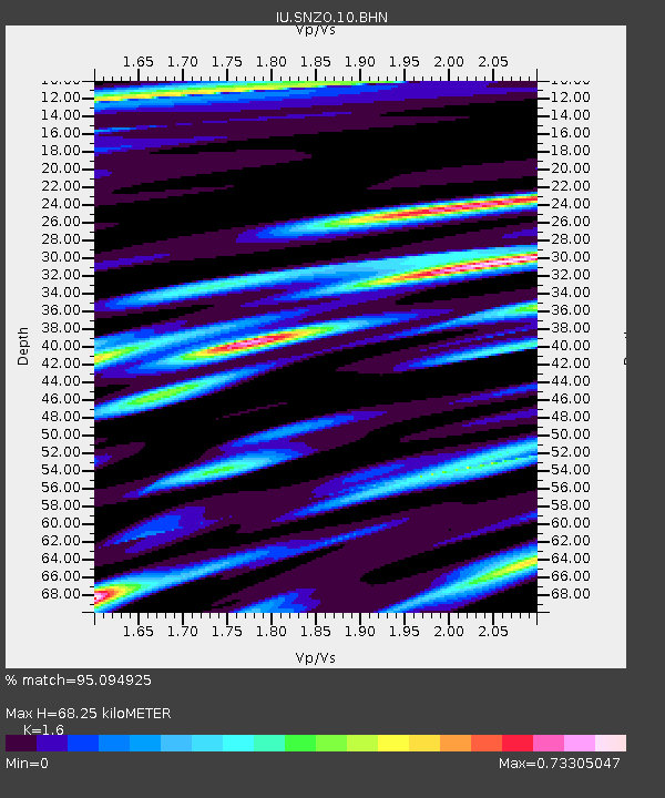
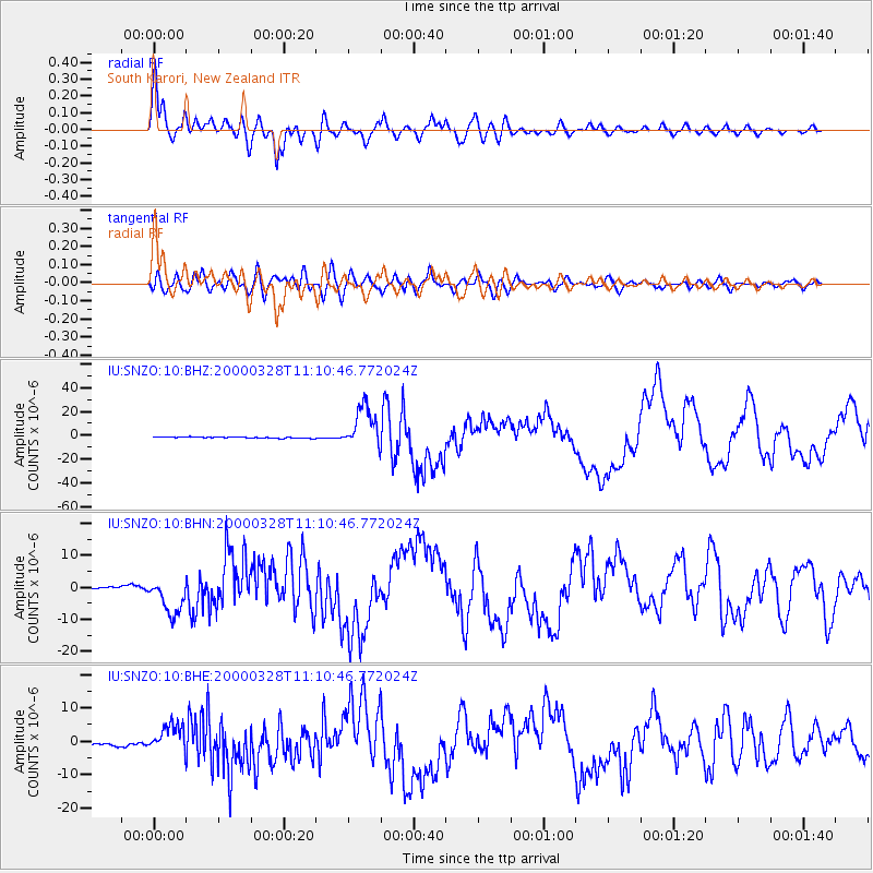
SNZO South Karori, New Zealand - Earthquake Result Viewer

Earthquake location: Volcano Islands, Japan Region
Earthquake latitude/longitude: 22.3/143.7
Earthquake time(UTC): 2000/03/28 (088) 11:00:22 GMT
Earthquake Depth: 126 km
Earthquake Magnitude: 6.8 MB, 7.6 MS, 7.6 MW, 7.6 MW
Earthquake Catalog/Contributor: WHDF/NEIC
Network: IU Global Seismograph Network (GSN - IRIS/USGS)
Station: SNZO South Karori, New Zealand
Lat/Lon: 41.31 S/174.70 E
Elevation: 62 m
Distance: 69.5 deg
Az: 155.556 deg
Baz: 329.431 deg
Ray Param: 0.05524276
Estimated Moho Depth: 68.25 km
Estimated Crust Vp/Vs: 1.60
Assumed Crust Vp: 6.461 km/s
Estimated Crust Vs: 4.038 km/s
Estimated Crust Poisson's Ratio: 0.18
Radial Match: 95.094925 %
Radial Bump: 400
Transverse Match: 86.17972 %
Transverse Bump: 400
SOD ConfigId: 3744
Insert Time: 2010-03-04 20:53:14.216 +0000
GWidth: 2.5
Max Bumps: 400
Tol: 0.001

Signal To Noise

ChannelStoNSTALTA
IU:SNZO:10:BHN:20000328T11:10:46.772024Z12.5643845.742286E-64.5702882E-7
IU:SNZO:10:BHE:20000328T11:10:46.772024Z7.5518084.306697E-65.702869E-7
IU:SNZO:10:BHZ:20000328T11:10:46.772024Z33.243731.7520699E-55.2703774E-7
Arrivals
Ps6.6 SECOND
PpPs26 SECOND
PsPs/PpSs33 SECOND