You are here: Home > Network List > IU - Global Seismograph Network (GSN - IRIS/USGS) Stations List
> Station SNZO South Karori, New Zealand > Earthquake Result Viewer
SNZO South Karori, New Zealand - Earthquake Result Viewer
| Earthquake location: |
Northern Molucca Sea |
| Earthquake latitude/longitude: |
1.3/126.2 |
| Earthquake time(UTC): |
2001/02/24 (055) 07:23:48 GMT |
| Earthquake Depth: |
35 km |
| Earthquake Magnitude: |
6.6 MB, 7.0 MS, 7.1 MW, 7.1 ME |
| Earthquake Catalog/Contributor: |
WHDF/NEIC |
|
| Network: |
IU Global Seismograph Network (GSN - IRIS/USGS) |
| Station: |
SNZO South Karori, New Zealand |
| Lat/Lon: |
41.31 S/174.70 E |
| Elevation: |
62 m |
|
| Distance: |
61.0 deg |
| Az: |
139.854 deg |
| Baz: |
301.17 deg |
| Ray Param: |
0.06110763 |
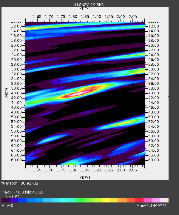
| Estimated Moho Depth: |
40.0 km |
| Estimated Crust Vp/Vs: |
1.82 |
| Assumed Crust Vp: |
6.461 km/s |
| Estimated Crust Vs: |
3.55 km/s |
| Estimated Crust Poisson's Ratio: |
0.28 |
|
| Radial Match: |
88.92782 % |
| Radial Bump: |
400 |
| Transverse Match: |
72.29552 % |
| Transverse Bump: |
400 |
| SOD ConfigId: |
3744 |
| Insert Time: |
2010-03-04 20:53:20.353 +0000 |
| GWidth: |
2.5 |
| Max Bumps: |
400 |
| Tol: |
0.001 |
|
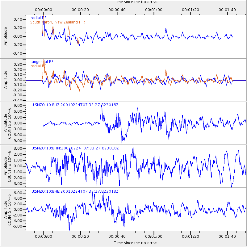
Signal To Noise
| Channel | StoN | STA | LTA |
| IU:SNZO:10:BHN:20010224T07:33:27.823018Z | 2.2489414 | 1.2755668E-6 | 5.671854E-7 |
| IU:SNZO:10:BHE:20010224T07:33:27.823018Z | 1.7891958 | 1.1866858E-6 | 6.63251E-7 |
| IU:SNZO:10:BHZ:20010224T07:33:27.823018Z | 7.083436 | 3.3926967E-6 | 4.78962E-7 |
| Arrivals |
| Ps | 5.3 SECOND |
| PpPs | 17 SECOND |
| PsPs/PpSs | 22 SECOND |


