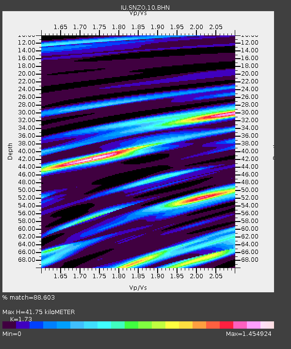
SNZO South Karori, New Zealand - Earthquake Result Viewer
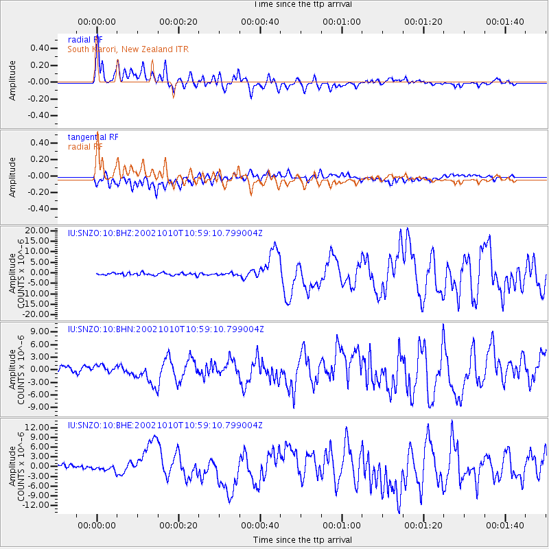
Earthquake location: Irian Jaya Region, Indonesia
Earthquake latitude/longitude: -1.8/134.3
Earthquake time(UTC): 2002/10/10 (283) 10:50:20 GMT
Earthquake Depth: 10 km
Earthquake Magnitude: 6.5 MB, 7.7 MS, 7.6 MW, 7.4 MW
Earthquake Catalog/Contributor: WHDF/NEIC
Network: IU Global Seismograph Network (GSN - IRIS/USGS)
Station: SNZO South Karori, New Zealand
Lat/Lon: 41.31 S/174.70 E
Elevation: 62 m
Distance: 53.6 deg
Az: 142.65 deg
Baz: 306.394 deg
Ray Param: 0.0659902
Estimated Moho Depth: 41.75 km
Estimated Crust Vp/Vs: 1.73
Assumed Crust Vp: 6.461 km/s
Estimated Crust Vs: 3.735 km/s
Estimated Crust Poisson's Ratio: 0.25
Radial Match: 88.603 %
Radial Bump: 400
Transverse Match: 70.48581 %
Transverse Bump: 400
SOD ConfigId: 4714
Insert Time: 2010-03-04 20:53:22.621 +0000
GWidth: 2.5
Max Bumps: 400
Tol: 0.001

Signal To Noise

ChannelStoNSTALTA
IU:SNZO:10:BHN:20021010T10:59:10.799004Z1.54151021.3046152E-68.463228E-7
IU:SNZO:10:BHE:20021010T10:59:10.799004Z0.79802397.9365316E-79.94523E-7
IU:SNZO:10:BHZ:20021010T10:59:10.799004Z0.826960274.684814E-75.6651015E-7
Arrivals
Ps5.0 SECOND
PpPs17 SECOND
PsPs/PpSs22 SECOND