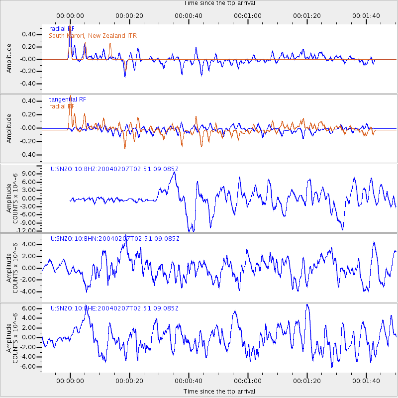
SNZO South Karori, New Zealand - Earthquake Result Viewer
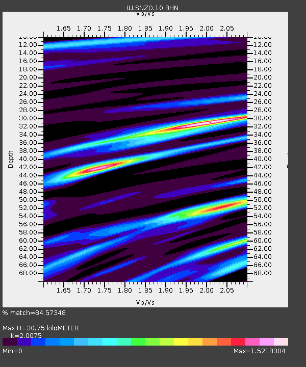
Earthquake location: Irian Jaya Region, Indonesia
Earthquake latitude/longitude: -4.0/135.0
Earthquake time(UTC): 2004/02/07 (038) 02:42:35 GMT
Earthquake Depth: 10 km
Earthquake Magnitude: 6.2 MB, 7.5 MS, 7.3 MW, 7.3 MW
Earthquake Catalog/Contributor: WHDF/NEIC
Network: IU Global Seismograph Network (GSN - IRIS/USGS)
Station: SNZO South Karori, New Zealand
Lat/Lon: 41.31 S/174.70 E
Elevation: 62 m
Distance: 51.4 deg
Az: 142.007 deg
Baz: 305.399 deg
Ray Param: 0.06744296
Estimated Moho Depth: 30.75 km
Estimated Crust Vp/Vs: 2.01
Assumed Crust Vp: 6.461 km/s
Estimated Crust Vs: 3.219 km/s
Estimated Crust Poisson's Ratio: 0.33
Radial Match: 84.57348 %
Radial Bump: 400
Transverse Match: 63.79737 %
Transverse Bump: 400
SOD ConfigId: 2459
Insert Time: 2010-03-04 20:53:30.878 +0000
GWidth: 2.5
Max Bumps: 400
Tol: 0.001

Signal To Noise

ChannelStoNSTALTA
IU:SNZO:10:BHN:20040207T02:51:09.085Z0.58839126.0170953E-71.0226352E-6
IU:SNZO:10:BHE:20040207T02:51:09.085Z2.06764322.3201912E-61.122143E-6
IU:SNZO:10:BHZ:20040207T02:51:09.085Z9.2891594.692224E-65.0512904E-7
Arrivals
Ps5.0 SECOND
PpPs14 SECOND
PsPs/PpSs19 SECOND