You are here: Home > Network List > IU - Global Seismograph Network (GSN - IRIS/USGS) Stations List
> Station SNZO South Karori, New Zealand > Earthquake Result Viewer
SNZO South Karori, New Zealand - Earthquake Result Viewer
| Earthquake location: |
Savu Sea |
| Earthquake latitude/longitude: |
-9.4/122.8 |
| Earthquake time(UTC): |
2004/04/23 (114) 01:50:30 GMT |
| Earthquake Depth: |
66 km |
| Earthquake Magnitude: |
6.5 MB, 6.7 MW, 6.7 MW |
| Earthquake Catalog/Contributor: |
WHDF/NEIC |
|
| Network: |
IU Global Seismograph Network (GSN - IRIS/USGS) |
| Station: |
SNZO South Karori, New Zealand |
| Lat/Lon: |
41.31 S/174.70 E |
| Elevation: |
62 m |
|
| Distance: |
55.6 deg |
| Az: |
134.079 deg |
| Baz: |
289.771 deg |
| Ray Param: |
0.06452908 |
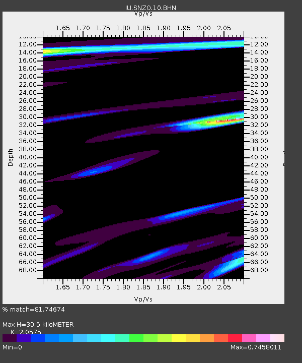
| Estimated Moho Depth: |
30.5 km |
| Estimated Crust Vp/Vs: |
2.06 |
| Assumed Crust Vp: |
6.461 km/s |
| Estimated Crust Vs: |
3.14 km/s |
| Estimated Crust Poisson's Ratio: |
0.35 |
|
| Radial Match: |
81.74674 % |
| Radial Bump: |
400 |
| Transverse Match: |
67.99012 % |
| Transverse Bump: |
400 |
| SOD ConfigId: |
2459 |
| Insert Time: |
2010-03-04 20:53:32.886 +0000 |
| GWidth: |
2.5 |
| Max Bumps: |
400 |
| Tol: |
0.001 |
|
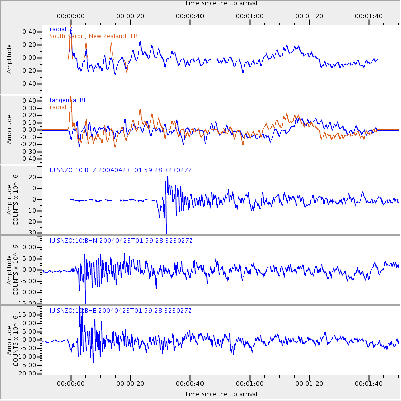
Signal To Noise
| Channel | StoN | STA | LTA |
| IU:SNZO:10:BHN:20040423T01:59:28.323027Z | 4.777036 | 3.0488613E-6 | 6.382328E-7 |
| IU:SNZO:10:BHE:20040423T01:59:28.323027Z | 10.511477 | 6.9314087E-6 | 6.5941333E-7 |
| IU:SNZO:10:BHZ:20040423T01:59:28.323027Z | 30.213055 | 1.0819214E-5 | 3.5809734E-7 |
| Arrivals |
| Ps | 5.2 SECOND |
| PpPs | 14 SECOND |
| PsPs/PpSs | 19 SECOND |


