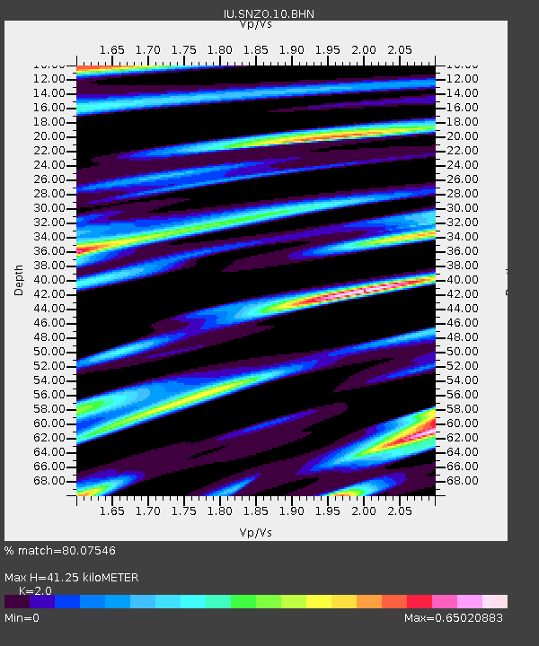
SNZO South Karori, New Zealand - Earthquake Result Viewer
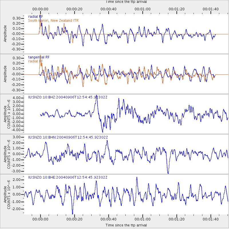
Earthquake location: South Sandwich Islands Region
Earthquake latitude/longitude: -55.4/-29.0
Earthquake time(UTC): 2004/09/06 (250) 12:42:59 GMT
Earthquake Depth: 10 km
Earthquake Magnitude: 6.0 MB, 6.5 MS, 6.9 MW, 6.8 MW
Earthquake Catalog/Contributor: WHDF/NEIC
Network: IU Global Seismograph Network (GSN - IRIS/USGS)
Station: SNZO South Karori, New Zealand
Lat/Lon: 41.31 S/174.70 E
Elevation: 62 m
Distance: 81.6 deg
Az: 197.809 deg
Baz: 166.6 deg
Ray Param: 0.047475137
Estimated Moho Depth: 41.25 km
Estimated Crust Vp/Vs: 2.00
Assumed Crust Vp: 6.461 km/s
Estimated Crust Vs: 3.231 km/s
Estimated Crust Poisson's Ratio: 0.33
Radial Match: 80.07546 %
Radial Bump: 400
Transverse Match: 57.780067 %
Transverse Bump: 400
SOD ConfigId: 2459
Insert Time: 2010-03-04 20:53:35.617 +0000
GWidth: 2.5
Max Bumps: 400
Tol: 0.001

Signal To Noise

ChannelStoNSTALTA
IU:SNZO:10:BHN:20040906T12:54:45.92302Z1.68997371.0556934E-66.246803E-7
IU:SNZO:10:BHE:20040906T12:54:45.92302Z0.91912924.8943934E-75.3250335E-7
IU:SNZO:10:BHZ:20040906T12:54:45.92302Z4.3733092.047914E-64.682756E-7
Arrivals
Ps6.5 SECOND
PpPs19 SECOND
PsPs/PpSs25 SECOND