You are here: Home > Network List > IU - Global Seismograph Network (GSN - IRIS/USGS) Stations List
> Station SNZO South Karori, New Zealand > Earthquake Result Viewer
SNZO South Karori, New Zealand - Earthquake Result Viewer
| Earthquake location: |
Near N Coast Of New Guinea, P.N.G. |
| Earthquake latitude/longitude: |
-2.4/141.2 |
| Earthquake time(UTC): |
1992/10/31 (305) 14:34:26 GMT |
| Earthquake Depth: |
33 km |
| Earthquake Magnitude: |
5.8 MB, 6.4 MS |
| Earthquake Catalog/Contributor: |
WHDF/NEIC |
|
| Network: |
IU Global Seismograph Network (GSN - IRIS/USGS) |
| Station: |
SNZO South Karori, New Zealand |
| Lat/Lon: |
41.31 S/174.70 E |
| Elevation: |
62 m |
|
| Distance: |
49.1 deg |
| Az: |
146.633 deg |
| Baz: |
313.159 deg |
| Ray Param: |
0.06886679 |
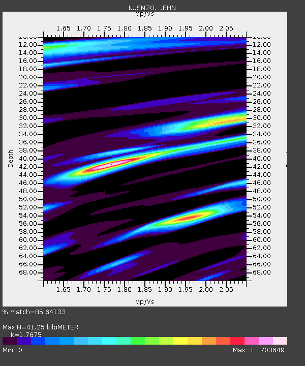
| Estimated Moho Depth: |
41.25 km |
| Estimated Crust Vp/Vs: |
1.77 |
| Assumed Crust Vp: |
6.461 km/s |
| Estimated Crust Vs: |
3.656 km/s |
| Estimated Crust Poisson's Ratio: |
0.26 |
|
| Radial Match: |
85.64133 % |
| Radial Bump: |
400 |
| Transverse Match: |
75.70623 % |
| Transverse Bump: |
400 |
| SOD ConfigId: |
16938 |
| Insert Time: |
2010-03-04 20:53:37.922 +0000 |
| GWidth: |
2.5 |
| Max Bumps: |
400 |
| Tol: |
0.001 |
|
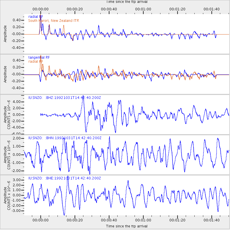
Signal To Noise
| Channel | StoN | STA | LTA |
| IU:SNZO: :BHN:19921031T14:42:40.200Z | 1.7271097 | 7.690068E-7 | 4.452565E-7 |
| IU:SNZO: :BHE:19921031T14:42:40.200Z | 2.6279316 | 1.0076096E-6 | 3.834231E-7 |
| IU:SNZO: :BHZ:19921031T14:42:40.200Z | 1.6870509 | 1.5538163E-6 | 9.210251E-7 |
| Arrivals |
| Ps | 5.2 SECOND |
| PpPs | 17 SECOND |
| PsPs/PpSs | 22 SECOND |


