You are here: Home > Network List > IU - Global Seismograph Network (GSN - IRIS/USGS) Stations List
> Station SNZO South Karori, New Zealand > Earthquake Result Viewer
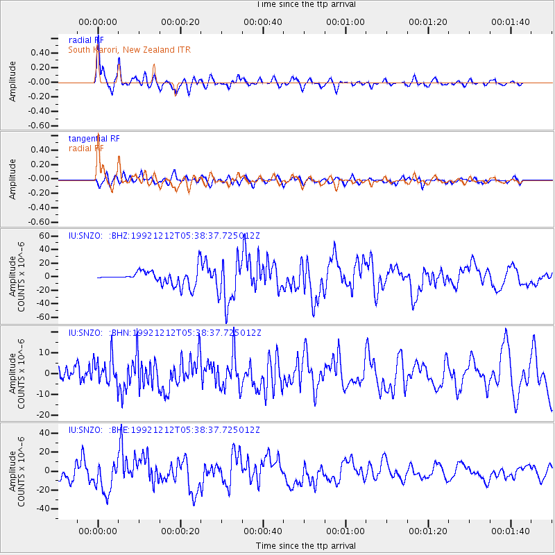
SNZO South Karori, New Zealand - Earthquake Result Viewer
| Earthquake location: |
Flores Region, Indonesia |
| Earthquake latitude/longitude: |
-8.5/121.9 |
| Earthquake time(UTC): |
1992/12/12 (347) 05:29:27 GMT |
| Earthquake Depth: |
35 km |
| Earthquake Magnitude: |
6.7 MB, 7.5 MS, 7.5 UNKNOWN |
| Earthquake Catalog/Contributor: |
WHDF/NEIC |
|
| Network: |
IU Global Seismograph Network (GSN - IRIS/USGS) |
| Station: |
SNZO South Karori, New Zealand |
| Lat/Lon: |
41.31 S/174.70 E |
| Elevation: |
62 m |
|
| Distance: |
56.8 deg |
| Az: |
134.195 deg |
| Baz: |
289.715 deg |
| Ray Param: |
0.06381857 |
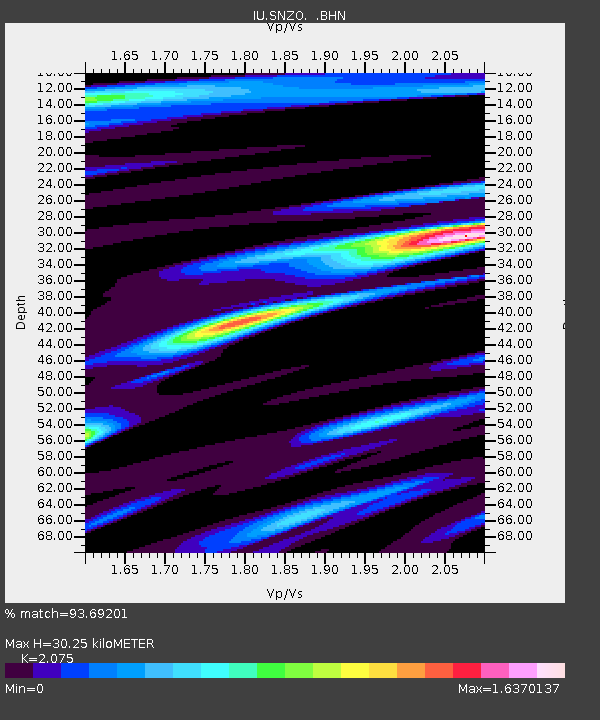
| Estimated Moho Depth: |
30.25 km |
| Estimated Crust Vp/Vs: |
2.08 |
| Assumed Crust Vp: |
6.461 km/s |
| Estimated Crust Vs: |
3.114 km/s |
| Estimated Crust Poisson's Ratio: |
0.35 |
|
| Radial Match: |
93.69201 % |
| Radial Bump: |
400 |
| Transverse Match: |
85.69622 % |
| Transverse Bump: |
400 |
| SOD ConfigId: |
16938 |
| Insert Time: |
2010-03-04 20:53:39.487 +0000 |
| GWidth: |
2.5 |
| Max Bumps: |
400 |
| Tol: |
0.001 |
|
Signal To Noise
| Channel | StoN | STA | LTA |
| IU:SNZO: :BHN:19921212T05:38:37.725012Z | 4.2011685 | 6.4188184E-6 | 1.5278652E-6 |
| IU:SNZO: :BHE:19921212T05:38:37.725012Z | 3.3324895 | 1.6580629E-5 | 4.9754485E-6 |
| IU:SNZO: :BHZ:19921212T05:38:37.725012Z | 3.096072 | 3.2879543E-5 | 1.0619761E-5 |
| Arrivals |
| Ps | 5.3 SECOND |
| PpPs | 14 SECOND |
| PsPs/PpSs | 19 SECOND |


