You are here: Home > Network List > IU - Global Seismograph Network (GSN - IRIS/USGS) Stations List
> Station SNZO South Karori, New Zealand > Earthquake Result Viewer
SNZO South Karori, New Zealand - Earthquake Result Viewer
| Earthquake location: |
Banda Sea |
| Earthquake latitude/longitude: |
-6.5/130.4 |
| Earthquake time(UTC): |
1992/12/20 (355) 20:52:42 GMT |
| Earthquake Depth: |
33 km |
| Earthquake Magnitude: |
6.6 MB, 7.1 MS, 7.0 UNKNOWN |
| Earthquake Catalog/Contributor: |
WHDF/NEIC |
|
| Network: |
IU Global Seismograph Network (GSN - IRIS/USGS) |
| Station: |
SNZO South Karori, New Zealand |
| Lat/Lon: |
41.31 S/174.70 E |
| Elevation: |
62 m |
|
| Distance: |
52.4 deg |
| Az: |
138.4 deg |
| Baz: |
298.871 deg |
| Ray Param: |
0.06670083 |
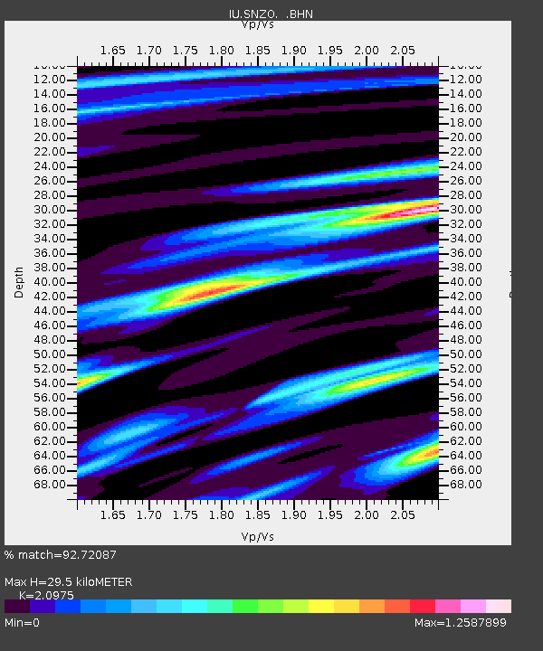
| Estimated Moho Depth: |
29.5 km |
| Estimated Crust Vp/Vs: |
2.10 |
| Assumed Crust Vp: |
6.461 km/s |
| Estimated Crust Vs: |
3.081 km/s |
| Estimated Crust Poisson's Ratio: |
0.35 |
|
| Radial Match: |
92.72087 % |
| Radial Bump: |
400 |
| Transverse Match: |
83.36384 % |
| Transverse Bump: |
400 |
| SOD ConfigId: |
16938 |
| Insert Time: |
2010-03-04 20:53:41.084 +0000 |
| GWidth: |
2.5 |
| Max Bumps: |
400 |
| Tol: |
0.001 |
|
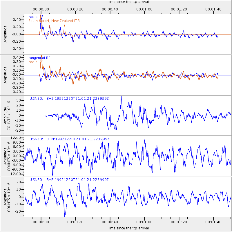
Signal To Noise
| Channel | StoN | STA | LTA |
| IU:SNZO: :BHN:19921220T21:01:21.223999Z | 2.8351119 | 4.2790116E-6 | 1.509292E-6 |
| IU:SNZO: :BHE:19921220T21:01:21.223999Z | 2.9258454 | 9.393121E-6 | 3.2103956E-6 |
| IU:SNZO: :BHZ:19921220T21:01:21.223999Z | 2.53157 | 1.372047E-5 | 5.4197476E-6 |
| Arrivals |
| Ps | 5.3 SECOND |
| PpPs | 13 SECOND |
| PsPs/PpSs | 19 SECOND |


