You are here: Home > Network List > IU - Global Seismograph Network (GSN - IRIS/USGS) Stations List
> Station SNZO South Karori, New Zealand > Earthquake Result Viewer
SNZO South Karori, New Zealand - Earthquake Result Viewer
| Earthquake location: |
Hokkaido, Japan Region |
| Earthquake latitude/longitude: |
43.4/143.3 |
| Earthquake time(UTC): |
1993/01/15 (015) 11:06:05 GMT |
| Earthquake Depth: |
100 km |
| Earthquake Magnitude: |
6.9 MB, 7.1 MS |
| Earthquake Catalog/Contributor: |
WHDF/NEIC |
|
| Network: |
IU Global Seismograph Network (GSN - IRIS/USGS) |
| Station: |
SNZO South Karori, New Zealand |
| Lat/Lon: |
41.31 S/174.70 E |
| Elevation: |
62 m |
|
| Distance: |
89.0 deg |
| Az: |
156.854 deg |
| Baz: |
337.648 deg |
| Ray Param: |
0.041997492 |
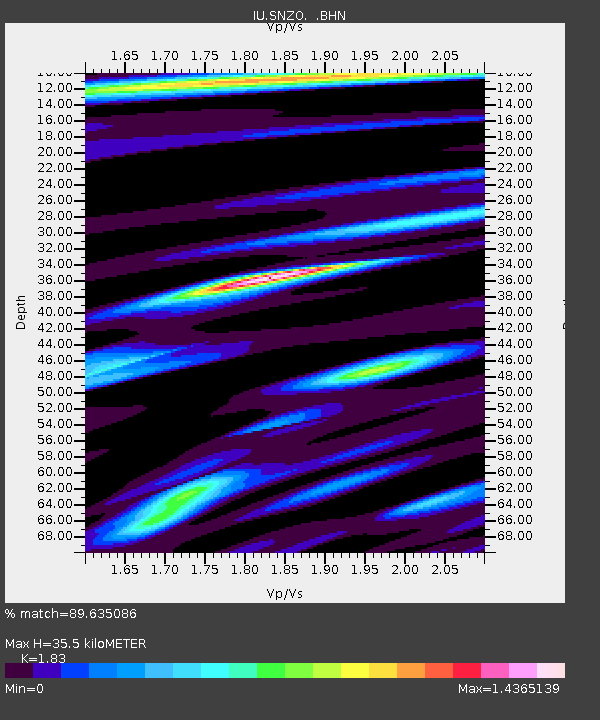
| Estimated Moho Depth: |
35.5 km |
| Estimated Crust Vp/Vs: |
1.83 |
| Assumed Crust Vp: |
6.461 km/s |
| Estimated Crust Vs: |
3.531 km/s |
| Estimated Crust Poisson's Ratio: |
0.29 |
|
| Radial Match: |
89.635086 % |
| Radial Bump: |
400 |
| Transverse Match: |
84.135826 % |
| Transverse Bump: |
400 |
| SOD ConfigId: |
16938 |
| Insert Time: |
2010-03-04 20:53:42.188 +0000 |
| GWidth: |
2.5 |
| Max Bumps: |
400 |
| Tol: |
0.001 |
|
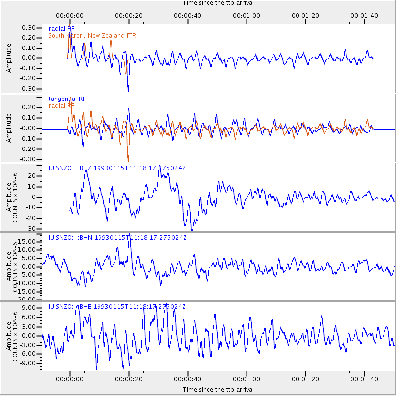
Signal To Noise
| Channel | StoN | STA | LTA |
| IU:SNZO: :BHN:19930115T11:18:17.275024Z | 1.8906763 | 7.0045057E-6 | 3.704762E-6 |
| IU:SNZO: :BHE:19930115T11:18:17.275024Z | 1.8737696 | 5.2711075E-6 | 2.8131035E-6 |
| IU:SNZO: :BHZ:19930115T11:18:17.275024Z | 2.0315473 | 2.1014319E-5 | 1.0343996E-5 |
| Arrivals |
| Ps | 4.7 SECOND |
| PpPs | 15 SECOND |
| PsPs/PpSs | 20 SECOND |


