You are here: Home > Network List > IU - Global Seismograph Network (GSN - IRIS/USGS) Stations List
> Station SNZO South Karori, New Zealand > Earthquake Result Viewer
SNZO South Karori, New Zealand - Earthquake Result Viewer
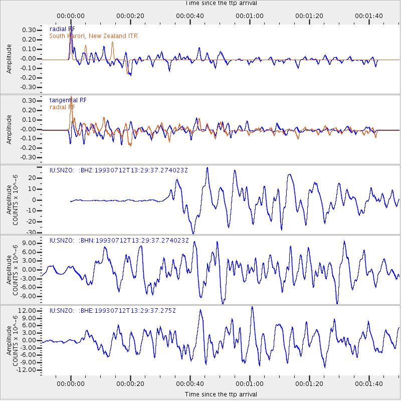
| Earthquake location: |
Hokkaido, Japan Region |
| Earthquake latitude/longitude: |
42.8/139.2 |
| Earthquake time(UTC): |
1993/07/12 (193) 13:17:11 GMT |
| Earthquake Depth: |
17 km |
| Earthquake Magnitude: |
6.7 MB, 7.6 MS, 7.3 UNKNOWN, 7.8 MW |
| Earthquake Catalog/Contributor: |
WHDF/NEIC |
|
| Network: |
IU Global Seismograph Network (GSN - IRIS/USGS) |
| Station: |
SNZO South Karori, New Zealand |
| Lat/Lon: |
41.31 S/174.70 E |
| Elevation: |
62 m |
|
| Distance: |
89.7 deg |
| Az: |
154.087 deg |
| Baz: |
334.744 deg |
| Ray Param: |
0.041727144 |
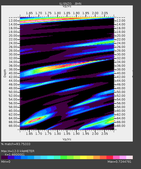
| Estimated Moho Depth: |
12.0 km |
| Estimated Crust Vp/Vs: |
1.68 |
| Assumed Crust Vp: |
6.461 km/s |
| Estimated Crust Vs: |
3.846 km/s |
| Estimated Crust Poisson's Ratio: |
0.23 |
|
| Radial Match: |
93.75333 % |
| Radial Bump: |
400 |
| Transverse Match: |
92.572365 % |
| Transverse Bump: |
400 |
| SOD ConfigId: |
16938 |
| Insert Time: |
2010-03-04 20:53:47.174 +0000 |
| GWidth: |
2.5 |
| Max Bumps: |
400 |
| Tol: |
0.001 |
|
Signal To Noise
| Channel | StoN | STA | LTA |
| IU:SNZO: :BHN:19930712T13:29:37.274023Z | 2.0803297 | 1.6152272E-6 | 7.7642846E-7 |
| IU:SNZO: :BHE:19930712T13:29:37.275Z | 1.3855588 | 8.225315E-7 | 5.93646E-7 |
| IU:SNZO: :BHZ:19930712T13:29:37.274023Z | 10.690572 | 3.862678E-6 | 3.6131632E-7 |
| Arrivals |
| Ps | 1.3 SECOND |
| PpPs | 4.9 SECOND |
| PsPs/PpSs | 6.2 SECOND |


