You are here: Home > Network List > IU - Global Seismograph Network (GSN - IRIS/USGS) Stations List
> Station SNZO South Karori, New Zealand > Earthquake Result Viewer
SNZO South Karori, New Zealand - Earthquake Result Viewer
| Earthquake location: |
South Pacific Ocean |
| Earthquake latitude/longitude: |
-10.8/-128.8 |
| Earthquake time(UTC): |
1994/02/12 (043) 04:16:26 GMT |
| Earthquake Depth: |
10 km |
| Earthquake Magnitude: |
6.3 MB, 6.5 MS, 6.6 UNKNOWN, 6.6 MW |
| Earthquake Catalog/Contributor: |
WHDF/NEIC |
|
| Network: |
IU Global Seismograph Network (GSN - IRIS/USGS) |
| Station: |
SNZO South Karori, New Zealand |
| Lat/Lon: |
41.31 S/174.70 E |
| Elevation: |
62 m |
|
| Distance: |
57.9 deg |
| Az: |
227.827 deg |
| Baz: |
75.162 deg |
| Ray Param: |
0.06318076 |
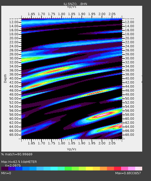
| Estimated Moho Depth: |
62.5 km |
| Estimated Crust Vp/Vs: |
2.10 |
| Assumed Crust Vp: |
6.461 km/s |
| Estimated Crust Vs: |
3.081 km/s |
| Estimated Crust Poisson's Ratio: |
0.35 |
|
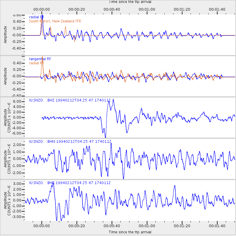
| Radial Match: |
90.99669 % |
| Radial Bump: |
400 |
| Transverse Match: |
80.79923 % |
| Transverse Bump: |
400 |
| SOD ConfigId: |
16938 |
| Insert Time: |
2010-03-04 20:53:53.399 +0000 |
| GWidth: |
2.5 |
| Max Bumps: |
400 |
| Tol: |
0.001 |
|
Signal To Noise
| Channel | StoN | STA | LTA |
| IU:SNZO: :BHN:19940212T04:25:47.174011Z | 1.1359248 | 3.6935293E-7 | 3.2515615E-7 |
| IU:SNZO: :BHE:19940212T04:25:47.174011Z | 1.5266391 | 6.0478163E-7 | 3.961523E-7 |
| IU:SNZO: :BHZ:19940212T04:25:47.174011Z | 6.9201665 | 1.609257E-6 | 2.3254599E-7 |
| Arrivals |
| Ps | 11 SECOND |
| PpPs | 29 SECOND |
| PsPs/PpSs | 40 SECOND |


