You are here: Home > Network List > IU - Global Seismograph Network (GSN - IRIS/USGS) Stations List
> Station SNZO South Karori, New Zealand > Earthquake Result Viewer
SNZO South Karori, New Zealand - Earthquake Result Viewer
| Earthquake location: |
Solomon Islands |
| Earthquake latitude/longitude: |
-6.5/154.9 |
| Earthquake time(UTC): |
1994/04/18 (108) 17:29:56 GMT |
| Earthquake Depth: |
43 km |
| Earthquake Magnitude: |
6.6 MB, 6.7 MS, 6.8 UNKNOWN, 6.7 MW |
| Earthquake Catalog/Contributor: |
WHDF/NEIC |
|
| Network: |
IU Global Seismograph Network (GSN - IRIS/USGS) |
| Station: |
SNZO South Karori, New Zealand |
| Lat/Lon: |
41.31 S/174.70 E |
| Elevation: |
62 m |
|
| Distance: |
38.9 deg |
| Az: |
156.041 deg |
| Baz: |
327.613 deg |
| Ray Param: |
0.07518926 |
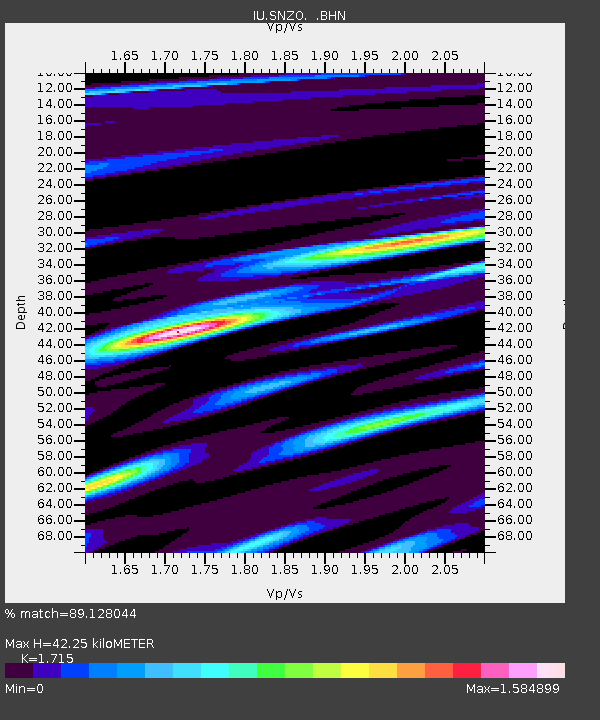
| Estimated Moho Depth: |
42.25 km |
| Estimated Crust Vp/Vs: |
1.72 |
| Assumed Crust Vp: |
6.461 km/s |
| Estimated Crust Vs: |
3.768 km/s |
| Estimated Crust Poisson's Ratio: |
0.24 |
|
| Radial Match: |
89.128044 % |
| Radial Bump: |
400 |
| Transverse Match: |
74.20157 % |
| Transverse Bump: |
400 |
| SOD ConfigId: |
16938 |
| Insert Time: |
2010-03-04 20:53:55.214 +0000 |
| GWidth: |
2.5 |
| Max Bumps: |
400 |
| Tol: |
0.001 |
|
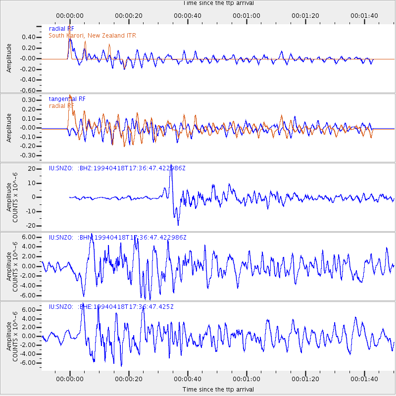
Signal To Noise
| Channel | StoN | STA | LTA |
| IU:SNZO: :BHN:19940418T17:36:47.422986Z | 3.5548172 | 2.475381E-6 | 6.963455E-7 |
| IU:SNZO: :BHE:19940418T17:36:47.425Z | 4.7244735 | 2.85296E-6 | 6.0386833E-7 |
| IU:SNZO: :BHZ:19940418T17:36:47.422986Z | 14.308055 | 8.536066E-6 | 5.965917E-7 |
| Arrivals |
| Ps | 5.0 SECOND |
| PpPs | 16 SECOND |
| PsPs/PpSs | 22 SECOND |


