You are here: Home > Network List > US - United States National Seismic Network Stations List
> Station WMOK Wichita Mountains, Oklahoma, USA > Earthquake Result Viewer
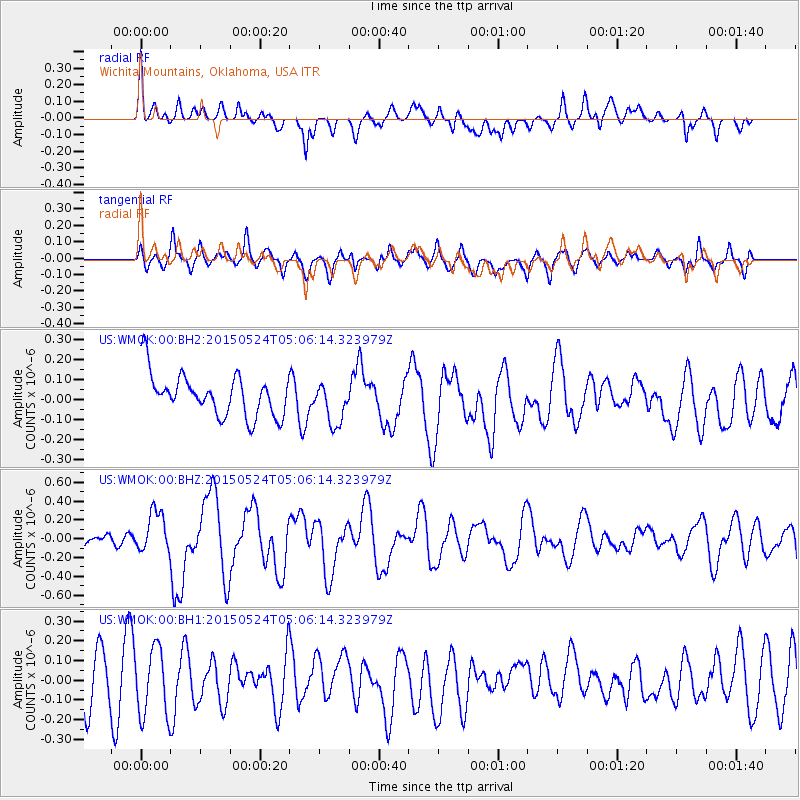
WMOK Wichita Mountains, Oklahoma, USA - Earthquake Result Viewer
*The percent match for this event was below the threshold and hence no stack was calculated.
| Earthquake location: |
Southern Mid-Atlantic Ridge |
| Earthquake latitude/longitude: |
-16.8/-14.2 |
| Earthquake time(UTC): |
2015/05/24 (144) 04:53:22 GMT |
| Earthquake Depth: |
10 km |
| Earthquake Magnitude: |
6.3 MWP |
| Earthquake Catalog/Contributor: |
NEIC PDE/NEIC COMCAT |
|
| Network: |
US United States National Seismic Network |
| Station: |
WMOK Wichita Mountains, Oklahoma, USA |
| Lat/Lon: |
34.74 N/98.78 W |
| Elevation: |
486 m |
|
| Distance: |
95.1 deg |
| Az: |
304.598 deg |
| Baz: |
106.816 deg |
| Ray Param: |
$rayparam |
*The percent match for this event was below the threshold and hence was not used in the summary stack. |
|
| Radial Match: |
61.317486 % |
| Radial Bump: |
400 |
| Transverse Match: |
40.162132 % |
| Transverse Bump: |
400 |
| SOD ConfigId: |
976571 |
| Insert Time: |
2015-06-07 05:17:02.327 +0000 |
| GWidth: |
2.5 |
| Max Bumps: |
400 |
| Tol: |
0.001 |
|
Signal To Noise
| Channel | StoN | STA | LTA |
| US:WMOK:00:BHZ:20150524T05:06:14.323979Z | 2.1378553 | 2.1648755E-7 | 1.01263886E-7 |
| US:WMOK:00:BH1:20150524T05:06:14.323979Z | 0.970777 | 1.716246E-7 | 1.7679096E-7 |
| US:WMOK:00:BH2:20150524T05:06:14.323979Z | 1.008604 | 1.0550221E-7 | 1.04602215E-7 |
| Arrivals |
| Ps | |
| PpPs | |
| PsPs/PpSs | |


