You are here: Home > Network List > IU - Global Seismograph Network (GSN - IRIS/USGS) Stations List
> Station SNZO South Karori, New Zealand > Earthquake Result Viewer
SNZO South Karori, New Zealand - Earthquake Result Viewer
| Earthquake location: |
New Ireland Region, P.N.G. |
| Earthquake latitude/longitude: |
-4.0/153.9 |
| Earthquake time(UTC): |
1995/06/24 (175) 06:58:06 GMT |
| Earthquake Depth: |
386 km |
| Earthquake Magnitude: |
6.2 MB, 6.8 UNKNOWN |
| Earthquake Catalog/Contributor: |
WHDF/NEIC |
|
| Network: |
IU Global Seismograph Network (GSN - IRIS/USGS) |
| Station: |
SNZO South Karori, New Zealand |
| Lat/Lon: |
41.31 S/174.70 E |
| Elevation: |
62 m |
|
| Distance: |
41.6 deg |
| Az: |
156.273 deg |
| Baz: |
327.801 deg |
| Ray Param: |
0.07199653 |
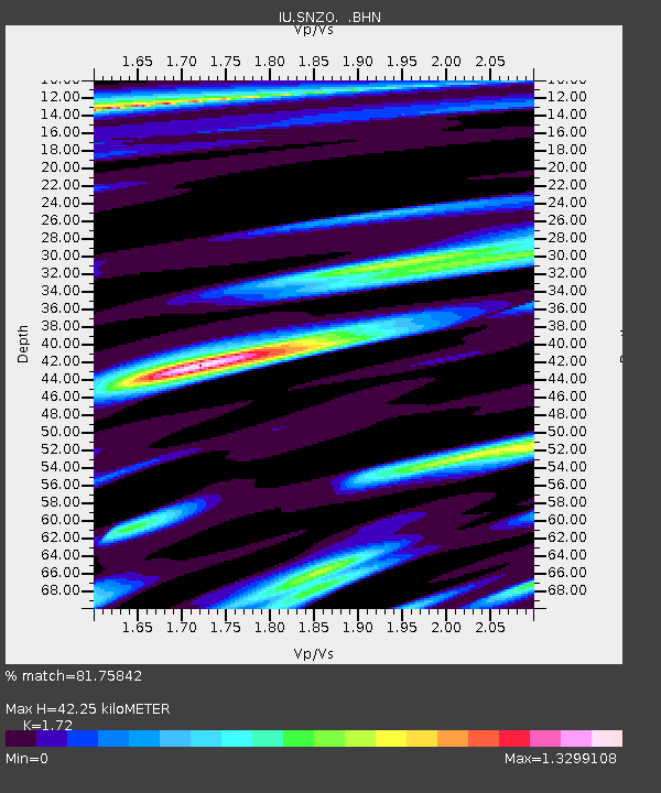
| Estimated Moho Depth: |
42.25 km |
| Estimated Crust Vp/Vs: |
1.72 |
| Assumed Crust Vp: |
6.461 km/s |
| Estimated Crust Vs: |
3.757 km/s |
| Estimated Crust Poisson's Ratio: |
0.24 |
|
| Radial Match: |
81.75842 % |
| Radial Bump: |
400 |
| Transverse Match: |
70.482346 % |
| Transverse Bump: |
400 |
| SOD ConfigId: |
6273 |
| Insert Time: |
2010-03-04 20:54:11.248 +0000 |
| GWidth: |
2.5 |
| Max Bumps: |
400 |
| Tol: |
0.001 |
|
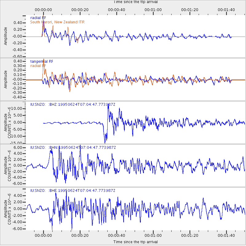
Signal To Noise
| Channel | StoN | STA | LTA |
| IU:SNZO: :BHN:19950624T07:04:47.773987Z | 4.0583754 | 2.5441152E-6 | 6.2688025E-7 |
| IU:SNZO: :BHE:19950624T07:04:47.773987Z | 2.6853127 | 1.955037E-6 | 7.280482E-7 |
| IU:SNZO: :BHZ:19950624T07:04:47.773987Z | 16.62345 | 6.1015558E-6 | 3.6704512E-7 |
| Arrivals |
| Ps | 5.0 SECOND |
| PpPs | 17 SECOND |
| PsPs/PpSs | 22 SECOND |


