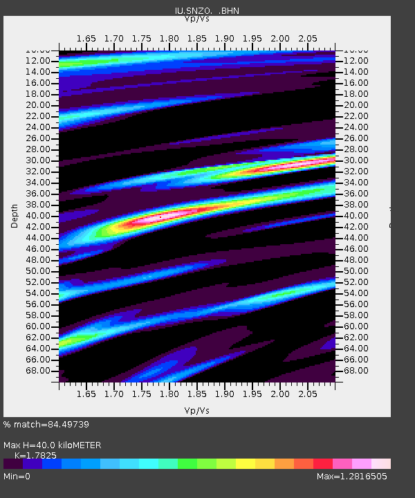
SNZO South Karori, New Zealand - Earthquake Result Viewer
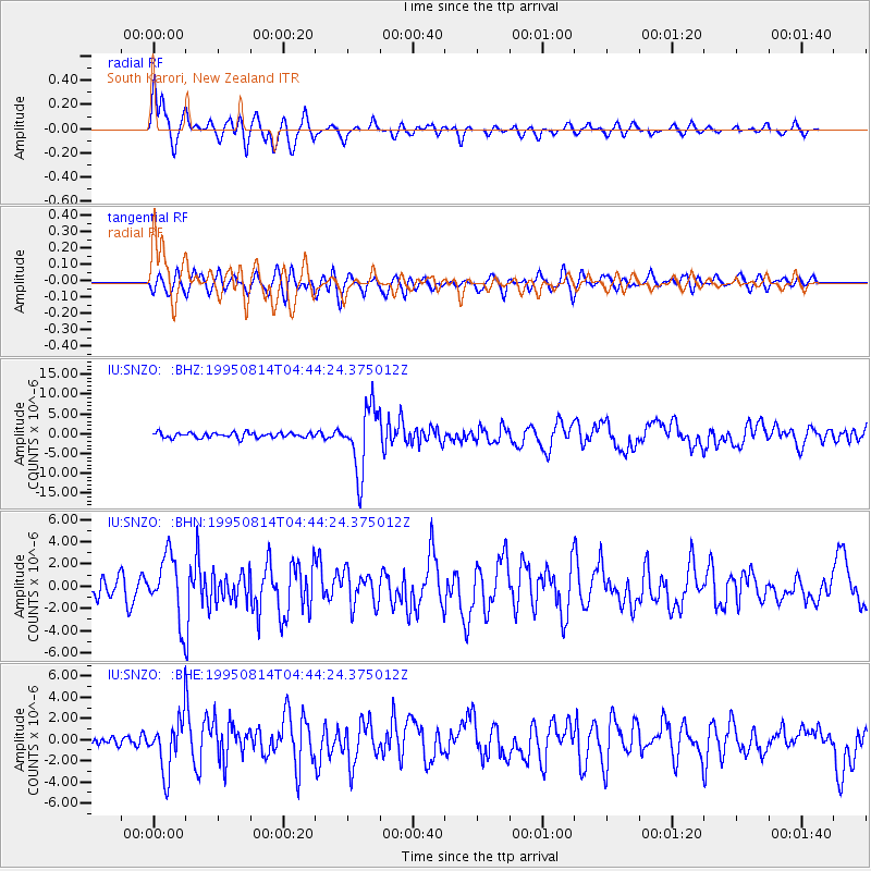
Earthquake location: New Britain Region, P.N.G.
Earthquake latitude/longitude: -4.8/151.5
Earthquake time(UTC): 1995/08/14 (226) 04:37:17 GMT
Earthquake Depth: 126 km
Earthquake Magnitude: 6.3 MB, 6.3 MS, 6.4 UNKNOWN
Earthquake Catalog/Contributor: WHDF/NEIC
Network: IU Global Seismograph Network (GSN - IRIS/USGS)
Station: SNZO South Karori, New Zealand
Lat/Lon: 41.31 S/174.70 E
Elevation: 62 m
Distance: 41.8 deg
Az: 153.587 deg
Baz: 323.955 deg
Ray Param: 0.073096976
Estimated Moho Depth: 40.0 km
Estimated Crust Vp/Vs: 1.78
Assumed Crust Vp: 6.461 km/s
Estimated Crust Vs: 3.625 km/s
Estimated Crust Poisson's Ratio: 0.27
Radial Match: 84.49739 %
Radial Bump: 400
Transverse Match: 66.649376 %
Transverse Bump: 400
SOD ConfigId: 6273
Insert Time: 2010-03-04 20:54:12.907 +0000
GWidth: 2.5
Max Bumps: 400
Tol: 0.001

Signal To Noise

ChannelStoNSTALTA
IU:SNZO: :BHN:19950814T04:44:24.375012Z4.20627362.8462312E-66.766634E-7
IU:SNZO: :BHE:19950814T04:44:24.375012Z4.0859972.51094E-66.1452323E-7
IU:SNZO: :BHZ:19950814T04:44:24.375012Z12.9056328.126017E-66.2964887E-7
Arrivals
Ps5.2 SECOND
PpPs16 SECOND
PsPs/PpSs21 SECOND