You are here: Home > Network List > IU - Global Seismograph Network (GSN - IRIS/USGS) Stations List
> Station SNZO South Karori, New Zealand > Earthquake Result Viewer
SNZO South Karori, New Zealand - Earthquake Result Viewer
| Earthquake location: |
Solomon Islands |
| Earthquake latitude/longitude: |
-6.5/155.0 |
| Earthquake time(UTC): |
1996/04/29 (120) 14:40:41 GMT |
| Earthquake Depth: |
44 km |
| Earthquake Magnitude: |
6.3 MB, 7.5 MS, 7.2 UNKNOWN, 6.8 ME |
| Earthquake Catalog/Contributor: |
WHDF/NEIC |
|
| Network: |
IU Global Seismograph Network (GSN - IRIS/USGS) |
| Station: |
SNZO South Karori, New Zealand |
| Lat/Lon: |
41.31 S/174.70 E |
| Elevation: |
62 m |
|
| Distance: |
38.8 deg |
| Az: |
156.109 deg |
| Baz: |
327.712 deg |
| Ray Param: |
0.075221814 |
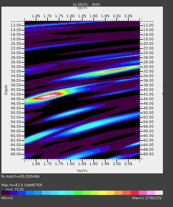
| Estimated Moho Depth: |
42.5 km |
| Estimated Crust Vp/Vs: |
1.71 |
| Assumed Crust Vp: |
6.461 km/s |
| Estimated Crust Vs: |
3.773 km/s |
| Estimated Crust Poisson's Ratio: |
0.24 |
|
| Radial Match: |
85.555466 % |
| Radial Bump: |
400 |
| Transverse Match: |
78.85876 % |
| Transverse Bump: |
400 |
| SOD ConfigId: |
6273 |
| Insert Time: |
2010-03-04 20:54:23.573 +0000 |
| GWidth: |
2.5 |
| Max Bumps: |
400 |
| Tol: |
0.001 |
|
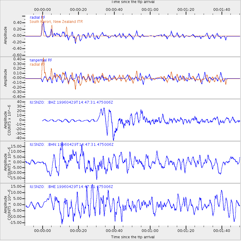
Signal To Noise
| Channel | StoN | STA | LTA |
| IU:SNZO: :BHN:19960429T14:47:31.475006Z | 6.2381296 | 6.746502E-6 | 1.0814944E-6 |
| IU:SNZO: :BHE:19960429T14:47:31.475006Z | 2.7665548 | 4.707034E-6 | 1.7014063E-6 |
| IU:SNZO: :BHZ:19960429T14:47:31.475006Z | 9.469349 | 1.5174513E-5 | 1.6024874E-6 |
| Arrivals |
| Ps | 5.1 SECOND |
| PpPs | 17 SECOND |
| PsPs/PpSs | 22 SECOND |


