You are here: Home > Network List > IU - Global Seismograph Network (GSN - IRIS/USGS) Stations List
> Station SNZO South Karori, New Zealand > Earthquake Result Viewer
SNZO South Karori, New Zealand - Earthquake Result Viewer

| Earthquake location: |
Banda Sea |
| Earthquake latitude/longitude: |
-6.5/129.9 |
| Earthquake time(UTC): |
2005/03/02 (061) 10:42:12 GMT |
| Earthquake Depth: |
202 km |
| Earthquake Magnitude: |
7.0 MB, 7.1 MW, 7.1 MW |
| Earthquake Catalog/Contributor: |
WHDF/NEIC |
|
| Network: |
IU Global Seismograph Network (GSN - IRIS/USGS) |
| Station: |
SNZO South Karori, New Zealand |
| Lat/Lon: |
41.31 S/174.70 E |
| Elevation: |
62 m |
|
| Distance: |
52.7 deg |
| Az: |
138.182 deg |
| Baz: |
298.428 deg |
| Ray Param: |
0.065846294 |
| Estimated Moho Depth: |
13.5 km |
| Estimated Crust Vp/Vs: |
1.60 |
| Assumed Crust Vp: |
6.461 km/s |
| Estimated Crust Vs: |
4.038 km/s |
| Estimated Crust Poisson's Ratio: |
0.18 |
|
| Radial Match: |
84.27186 % |
| Radial Bump: |
400 |
| Transverse Match: |
64.80942 % |
| Transverse Bump: |
400 |
| SOD ConfigId: |
2455 |
| Insert Time: |
2010-03-04 20:54:27.513 +0000 |
| GWidth: |
2.5 |
| Max Bumps: |
400 |
| Tol: |
0.001 |
|
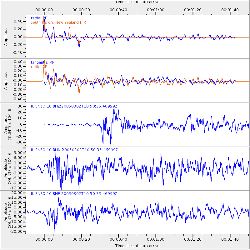
Signal To Noise
| Channel | StoN | STA | LTA |
| IU:SNZO:10:BHN:20050302T10:50:35.46999Z | 4.9238224 | 2.6768644E-6 | 5.436558E-7 |
| IU:SNZO:10:BHE:20050302T10:50:35.46999Z | 4.794296 | 5.366353E-6 | 1.1193205E-6 |
| IU:SNZO:10:BHZ:20050302T10:50:35.46999Z | 15.230754 | 1.1565348E-5 | 7.5934184E-7 |
| Arrivals |
| Ps | 1.3 SECOND |
| PpPs | 5.1 SECOND |
| PsPs/PpSs | 6.4 SECOND |


