You are here: Home > Network List > IU - Global Seismograph Network (GSN - IRIS/USGS) Stations List
> Station SNZO South Karori, New Zealand > Earthquake Result Viewer
SNZO South Karori, New Zealand - Earthquake Result Viewer
| Earthquake location: |
Banda Sea |
| Earthquake latitude/longitude: |
-5.5/128.1 |
| Earthquake time(UTC): |
2006/01/27 (027) 16:58:53 GMT |
| Earthquake Depth: |
397 km |
| Earthquake Magnitude: |
7.0 MB, 7.6 MW, 7.5 MW |
| Earthquake Catalog/Contributor: |
WHDF/NEIC |
|
| Network: |
IU Global Seismograph Network (GSN - IRIS/USGS) |
| Station: |
SNZO South Karori, New Zealand |
| Lat/Lon: |
41.31 S/174.70 E |
| Elevation: |
62 m |
|
| Distance: |
54.7 deg |
| Az: |
137.905 deg |
| Baz: |
297.643 deg |
| Ray Param: |
0.06374051 |
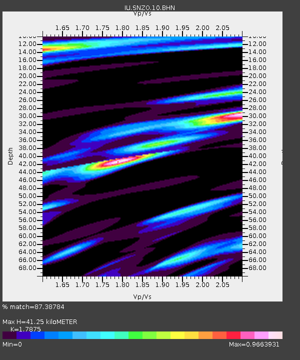
| Estimated Moho Depth: |
41.25 km |
| Estimated Crust Vp/Vs: |
1.79 |
| Assumed Crust Vp: |
6.461 km/s |
| Estimated Crust Vs: |
3.615 km/s |
| Estimated Crust Poisson's Ratio: |
0.27 |
|
| Radial Match: |
87.38784 % |
| Radial Bump: |
400 |
| Transverse Match: |
71.68427 % |
| Transverse Bump: |
400 |
| SOD ConfigId: |
4977 |
| Insert Time: |
2010-03-04 20:54:38.275 +0000 |
| GWidth: |
2.5 |
| Max Bumps: |
400 |
| Tol: |
0.001 |
|
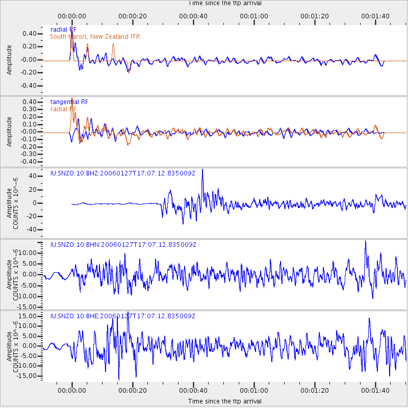
Signal To Noise
| Channel | StoN | STA | LTA |
| IU:SNZO:10:BHN:20060127T17:07:12.835009Z | 3.3731794 | 2.6296664E-6 | 7.795809E-7 |
| IU:SNZO:10:BHE:20060127T17:07:12.835009Z | 4.30494 | 4.4274543E-6 | 1.028459E-6 |
| IU:SNZO:10:BHZ:20060127T17:07:12.835009Z | 17.707037 | 1.0313144E-5 | 5.8243194E-7 |
| Arrivals |
| Ps | 5.3 SECOND |
| PpPs | 17 SECOND |
| PsPs/PpSs | 22 SECOND |


